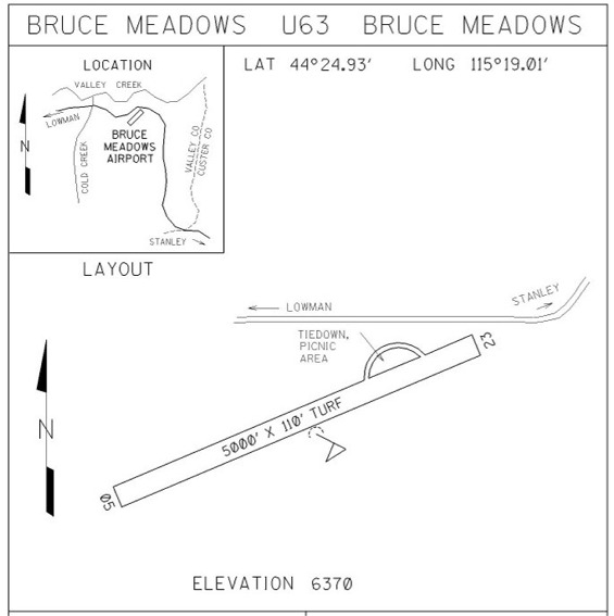
Sign in or Register
    • Featured
    • Recreational
    • Restricted
    • Off-Airport
    • Abandoned
    • Outpost
    • Home
    • Explore
    • Shop

    BRUCE MEADOWS, ID

    • Overview
    • Reviews / PIREPs 0
    • Events
    • Videos
    • prev
    • next
    • Bookmark
    • Share
    • Leave a Review / PIREP
    • Report
    • prev
    • next
    Description

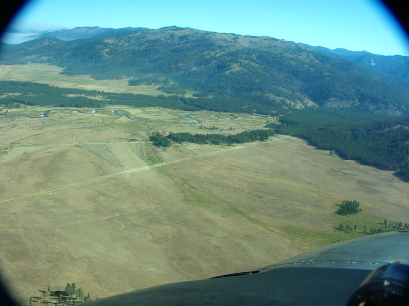
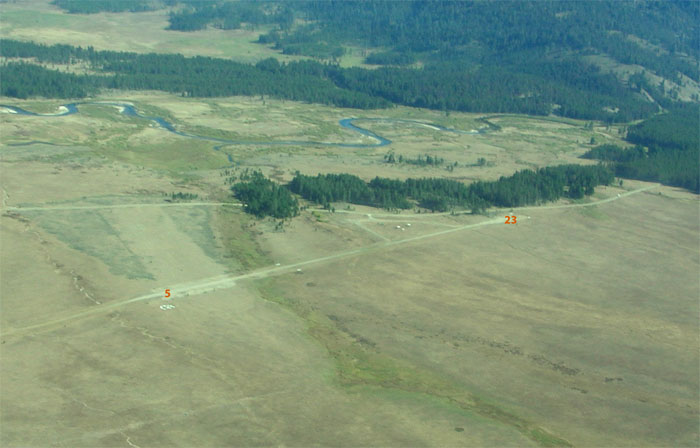
    Bruce Meadows is located in a large meadow  just outside the Frank Church River of No Return Wilderness, one mile to the south.  This is a roaded area and the nearby Boundary Creek Campground is a loading for whitewater boaters during higher water.

    Camping
    There is a table, fire pit and pit toilet at the northeast end of the airstrip.

    Tiedowns are located near the camp sites on the northeast end of the airstrip. 

    Runway
    • Length

      5000

    • Width

      110

    • Surface

      TURF-DIRT-G

    Details
    • Facility ID

      U63

    • Elevation

      6370

    • CTAF

      122.9

    • State

      ID

    Gallery
    Location

    Lat: 44.41545916667 , Long: -115.31677111111 - IDAHO, USA

    Get Directions
    Categories
    • Recreational
    Tags
    • Mountains
    Region
    • Northwest Mountain
    Ownership
    • Public
    Author
    shortfield
    mood_bad
  • No comments yet.
  • Add a review

    Leave a Reply · Cancel reply

    You must be logged in to post a comment.

    Related Videos
    Prev 1 of 16 Next
    • Bruce Meadows Landing

      Bruce Meadows Landing

      high altitude Idaho mountain airstrip
      #Idahomountainflying
    • Bruce Meadows, ID

      Bruce Meadows, ID

      "I like Bruce Meadows becasue it is a good strip for less experienced pilots. Even so, it is important to watch the DA there." ~ Todd
    • Bruce Meadows - Depart & Land

      Bruce Meadows - Depart & Land

    • Bruce Meadows landing pronghorn near miss

      Bruce Meadows landing pronghorn near miss

    • Flying in idaho...Stanley, Graham, Bruce Meadows, Upper Loon...Sulphur Creek Ranch

      Flying in idaho...Stanley, Graham, Bruce Meadows, Upper Loon...Sulphur Creek Ranch

      Flying in Idaho's backcountry
    • Fatal Midair Collision At Idaho Backcountry Fly-In

      Fatal Midair Collision At Idaho Backcountry Fly-In

      On June 28, 2013, about 0948 mountain daylight time, a Piper PA-22-135 Tri-Pacer, N1540P, and a Piper PA-28R-200 Arrow, N2108T, collided midair while on final approach to landing at the Johnson Creek Airport (3U2), Yellow Pine, Idaho.

      The private pilot of the Tri-Pacer and his pilot-rated passenger sustained serious injuries. The private pilot of the Arrow sustained serious injuries. Tragically, his 20-month-old son sustained fatal injuries. The child was secured in a CARES child restraint.

      A review of the recorded CTAF transmissions revealed that both pilots were transmitting their positions within the airport traffic pattern, corroborating their reports that they did so. It could not be determined why neither pilot heard the other pilot’s position reports and the NTSB found it likely that both pilots were not adequately monitoring other aircraft position reports while in the pattern.

      The NTSB report states "If either pilot had heard the other pilot’s position reports, it is likely that the collision would not have occurred." (Vigilance is such a common theme.)

      Both NTSB accident reports are included as part of a larger document repository containing investigative information about this accident. Those documents, which include the CTAF transcript, can be found at https://tiny.cc/idahomidair.

      ~~~~~~~~~~

      IMPORTANT

      The sole fatality in this accident was the Arrow pilot's two year old son. Please consider that when commenting.

      As the mostly-benevolent dictator of this place I am the sole authority on decorum. Inappropriate comments may be removed without warning.

      ~~~~~

      Got a story tip? Email news@whatyouhaventseen.com.
      (Keep in mind that we don’t publish footage that has already been published elsewhere.)
    • Wings and Wolves - Idaho Back Country June 2016

      Wings and Wolves - Idaho Back Country June 2016

      We took a trip into the Idaho wilderness around Bruce Meadows and Bull Trout Lake. The airstrip at Bruce Meadows attracted an Army Apache helicopter as well as civilian mountain fliers. The opening scenes, not far from Bull Trout Lake, show wolves shadowing an elk. Later, huge sandhill cranes are seen before the aircraft get active at Bruce Meadows. Have you subscribed to the Airailimages Channel? Thanks!
    • Upper Loon Airstrip (U72)

      Upper Loon Airstrip (U72)

      Landing at Upper Loon to visit the Diamond D Ranch. Arrival from Stanley.
    • Bruce Meadows interviews

      Bruce Meadows interviews

      ignore the pictures.
    • Landing at Donnelly U84

      Landing at Donnelly U84

      One of my better landings
    • Krassel Landing

      Krassel Landing

      Landing and Takeoff at Krassel Ranger Station Airstrip on the South Fork of the Salmon River in Idaho. 2016
    • Big Creek, ID (U60) - Approach and Landing

      Big Creek, ID (U60) - Approach and Landing

      Approach and Landing at Big Creek (U60) in June in a Cessna 182. There are several ways to approach this landing, and since it was my first time we took the extended route flying through the bottom of the mountain for a nice long approach. You can make a shorter left base if you are familiar with the terrain, or the mountain also supports a right base if you can turn around in the bowl to the north of the airstrip. As always use lots of caution and careful planning when going into new mountainous airstrips.

      Read more at https://airplaneacademy.com where we write about aviation tips, tricks, and FAQs.
    Prev 1 of 16 Next

    You May Also Be Interested In

    SULPHUR CREEK RANCH, ID

    http://www.sulphurcreekranch.comSulphur Creek Ranch (ID74) is a private strip and ranch located on the…
    • 44.53656972222, -115.35094083333
    • Restricted

    DEADWOOD DAM AIRSTRIP, ID

    Located on the shore of the clear water Deadwood Reservoir.  Although the setting is beautiful, the approach…
    • 44.29777777778, -115.64138888889
    • Restricted

    WARM SPRINGS CREEK, ID

    Tie downs opposite wind sock mid field.  USFS campsite behind the tie downs.   Trail to hot springs is at…
    • 44.14222222222, -115.31405555556
    • Recreational

    © 2000-2021 shortfield.com

    Cart

      • Featured
      • Recreational
      • Restricted
      • Off-Airport
      • Abandoned
      • Outpost
      • Facebook
      • Twitter
      • WhatsApp
      • Telegram
      • LinkedIn
      • Tumblr
      • VKontakte
      • Mail
      • Copy link