Sign in or Register
    • Featured
    • Recreational
    • Restricted
    • Off-Airport
    • Abandoned
    • Outpost
    • Home
    • Explore
    • STOL Gear
    • Search Airstrips

    DEADWOOD DAM AIRSTRIP, ID

    • Overview
    • Reviews / PIREPs 0
    • Videos
    • Events
    • prev
    • next
    • Leave a Review / PIREP
    • Bookmark
    • Report
    • Share
    • prev
    • next
    Description

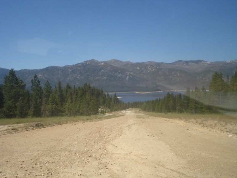
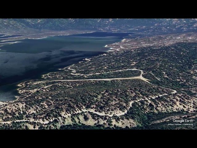
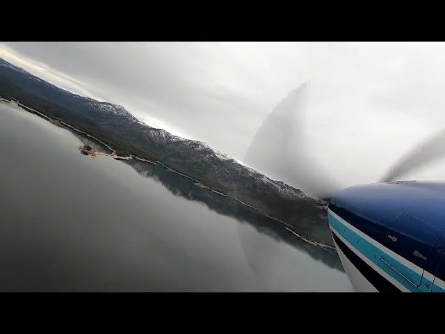
    Perched on the southeast shore of Deadwood Reservoir, this backcountry strip offers a scenic but demanding arrival. The approach comes in over the water, and the runway climbs steeply uphill — keep power on after touchdown to carry the aircraft all the way to the top. Before landing, check for vehicle traffic on the road that crosses the upper end of the runway. Parking and tie-downs are available at the top.

    Camping — Several campgrounds are within easy reach: Cozy Cove, Howers, Barney's, and Riverside. A rustic Forest Service cabin is also available with advance reservations through the Lowman Ranger District at (208) 259-3361.

    Fishing — The reservoir is reported to hold trout, Kokanee, Atlantic salmon, and whitefish.

    Runway
    • Length

      1800

    • Width

      50

    • Surface

      DIRT

    Details
    • Facility ID

      ID86

    • Elevation

      5489

    • CTAF

      122.9

    • State

      Idaho

    Gallery
    Location

    Lat: 44.29777777778 , Long: -115.64138888889 - IDAHO, USA

    Get Directions
    Flyover Video
    Prev 1 of 1 Next
    • Airstrip Flyover - Deadwood Reservoir, Idaho

      Airstrip Flyover - Deadwood Reservoir, Idaho

      ​ @shortfieldvideos
    Prev 1 of 1 Next
    Categories
    • Restricted
    Tags
    • Mountains
    • Lakes/Rivers
    • Fishing
    • Camping
    Region
    • Northwest Mountain
    Ownership
    • Public
    Author
    shortfield

    Land here, before you land out there!

    mood_bad
  • No reviews/PIREPs have been posted yet.

  • Add a review

    Leave a Reply · Cancel reply

    You must be logged in to post a comment.

    Shortfield Playlist
    Prev 1 of 2 Next
    • Deadwood Reservoir Airstrip, ID Flyover

      Deadwood Reservoir Airstrip, ID Flyover

      Very steep landing grade on this one, as the runway climbs up the mountain itself. But the airfield is private.
    • Take off and landing at Deadwood Reservoir airstrip

      Take off and landing at Deadwood Reservoir airstrip

      Deadwood Reservoir Airstrip
      ALT 5400 ft lenght 1500 ft 8% slope
    • Landing at Deadwood Reservoir Int'l Airport, Idaho

      Landing at Deadwood Reservoir Int'l Airport, Idaho

      Cessna 182 - Nick, Jeff & Carter - 6.26.2010
    • Taking Off at Deadwood Reservoir Int'l Airport, Idaho

      Taking Off at Deadwood Reservoir Int'l Airport, Idaho

      Cessna 182 - Nick, Jeff & Carter - 6.26.2010
    • Deadwood Reservoir airstrip take off

      Deadwood Reservoir airstrip take off

      6/26/2010 Take off from Deadwood airstrip
    • Deadwood Landing

      Deadwood Landing

      Deadwood Reservoir near Cascade, Idaho. 1800 foot strip of which the bottom several hundred feet are unusable due to trees on approach end. 6% grade.
    Prev 1 of 2 Next
    YouTube Search
    Prev 1 of 10 Next
    • ID86 - Deadwood Dam Airstrip | Cessa 140

      ID86 - Deadwood Dam Airstrip | Cessa 140

      ID86 - Deadwood Dam Airstrip | Cessa 140

      https://www.airnav.com/airport/ID86
    • Deadwood Landing

      Deadwood Landing

      Deadwood Reservoir near Cascade, Idaho. 1800 foot strip of which the bottom several hundred feet are unusable due to trees on approach end. 6% grade.
    • Kodiak 100 departed Wilson Bar USFS (C48) airstrip in Idaho Backcountry

      Kodiak 100 departed Wilson Bar USFS (C48) airstrip in Idaho Backcountry

    • Schafer Meadows Airstrip Project: 2020

      Schafer Meadows Airstrip Project: 2020

      Schafer Meadows is the last remaining active airstrip within a designated wilderness area in the state of Montana, located 14 miles from the nearest trailhead in the Bob Marshall Wilderness Complex. In 2020 the U.S. Forest Service began the work of restoring the historic airstrip using a team of mules and two vintage graders -- a process that had not been completed since the Great Bear Wilderness was designated in 1978.

      Find Part 2 with the work done in 2021 here: https://youtu.be/FiV9JCoQRHk

      Video provided by Fred and Nancy Flint.
    • Landing_Deadwood_Dam_Airstrip.mp4

      Landing_Deadwood_Dam_Airstrip.mp4

      Elevation: 5489 ft.
      Ident: ID86
      Runway NE/SW
      Dimensions: 1800 x 50 ft. / 549 x 15 m
      - HIGH RIDGE AT E END.
      - RWY HAS 6 PER CENT GRADE SLOPING DOWN E TO W.
      - ONE WAY LANDING FM W TO E. TKOF E TO W.
    • Takeoff downhill

      Takeoff downhill

      Deadwood Dam airstrip in Idaho
      Elev. 5700ft, 1800ft rwy, land 06 takeoff 24 only due to slope of rwy
    Prev 1 of 10 Next

    You May Also Be Interested In

    BRUCE MEADOWS, ID

    Bruce Meadows is located in a large meadow  just outside the Frank Church River of No Return Wilderness,…
    • 44.41545916667, -115.31677111111
    • Recreational

    WARM SPRINGS CREEK, ID

    Warm Springs Airport is a beautiful grass airstrip with onsite camping and a nearby hot springs.  The runway…
    • 44.14222222222, -115.31405555556
    • Recreational

    GARDEN VALLEY, ID

    Runways: 10/28 turf Dimensions: 3850' x 125' Recommend landing runway 10 (upstream), takeoff runway…
    • 44.06694444444, -115.93127777778
    • Recreational

    © 2000-2025 shortfield.com

    Cart

      • Featured
      • Recreational
      • Restricted
      • Off-Airport
      • Abandoned
      • Outpost
      • Facebook
      • Twitter
      • Mail
      • Copy link