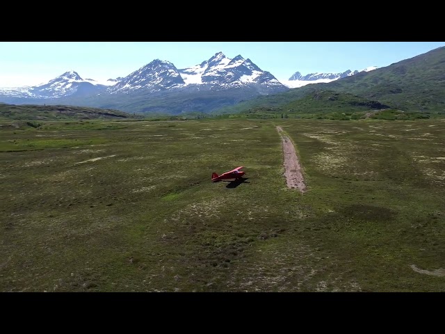
Sign in or Register
    • Featured
    • Recreational
    • Restricted
    • Off-Airport
    • Abandoned
    • Outpost
    • Home
    • Explore
    • Shop

    Tebay Lake, AK

    • Overview
    • Reviews / PIREPs 0
    • Events
    • Videos
    • prev
    • next
    • Bookmark
    • Share
    • Leave a Review / PIREP
    • Report
    • prev
    • next
    Runway
    • Length

      ?

    • Width

      ?

    • Surface

      TURF

    Details
    • Facility ID

      No ID 193

    • Elevation

      1900

    • CTAF

      122.9

    • State

      AK

    Location

    Lat: 61.18090478909 , Long: -144.39085713614 - , USA

    Get Directions
    Categories
    • Recreational
    Region
    • Alaska
    Ownership
    • Public
    Author
    shortfield
    mood_bad
  • No comments yet.
  • Add a review

    Leave a Reply · Cancel reply

    You must be logged in to post a comment.

    Related Videos
    Prev 1 of 2 Next
    • Tebay Lake Airstrip | Wrangell - St. Elias National Park, Alaska | Geoff Oliver

      Tebay Lake Airstrip | Wrangell - St. Elias National Park, Alaska | Geoff Oliver

      Tebay Lake airstrip (1,000 feet +/-), Wrangell - St. Elias National Park, Alaska, is located about 50 miles southwest of McCarthy, Alaska.
    • Tebay lake

      Tebay lake

      Summer back country camping trip Wrangel-St.Ellias National Park
    • Alaska - Landing at Tebay Lakes

      Alaska - Landing at Tebay Lakes

      Alaska 2010 Trip to Tebay Lakes. This is a video of us landing in the bush plane.
    • Alaskan Paradise

      Alaskan Paradise

      With his season in Alaska coming to a close, Brendan takes advantage of the unusually warm and dry October weather to embark on a final solo adventure. Flying into the heart of the Wrangell Mountains, Brendan had been interested in paddling the Tebay River for years. Featuring both solid whitewater and salmon fishing holes, it was a perfect place to wrap up another season in this remote and wild corner of the world.

      Littered with evidence of heavy wolf, bear and moose presence, the first part of the Tebay was a little intimidating. But after paddling down into the canyon, the threat of large critter encounters waned and the epic paddling and fishing commenced. Checking off both a successful mission on the Tebay and catching the fifth and final species of pacific salmon—reaching a goal to catch them all in one season—Brendan says goodbye to Alaska…until next season.
    • Alaska Mountain Kingdom | Ultima Thule Lodge Plane-Accessed Skiing

      Alaska Mountain Kingdom | Ultima Thule Lodge Plane-Accessed Skiing

      Discover the magic of the Wrangells and the largest wilderness area in the world with Ultima Thule Lodge's plane-accessed ski program. Featuring Paul Claus, Chris Davenport, and the late Peter Inglis.
    • Hubert's Landing | Wrangell Mountains, Alaska | Geoff Oliver

      Hubert's Landing | Wrangell Mountains, Alaska | Geoff Oliver

      Hubert's Landing (800 feet +/-), toe of the Chitina Glacier, Wrangell - St Elias National Park & Preserve, Alaska.
    • Wrangell-St. Elias N.P., Alaska - Flight from Ultima Thule Lodge to Icy Bay 2021 Jul. 05

      Wrangell-St. Elias N.P., Alaska - Flight from Ultima Thule Lodge to Icy Bay 2021 Jul. 05

      Our flight in Wrangell-St. Elias N.P., Alaska, from Ultima Thule Lodge to Icy Bay, had some astonishing views of mountains, glaciers, valleys, glacier pools, and icebergs, including the mesmerizing beauty of Bagley Icefield
    • Wrangell-St. Elias N.P., Alaska - Ultima Thule Lodge room tour 2021 Jul. 04

      Wrangell-St. Elias N.P., Alaska - Ultima Thule Lodge room tour 2021 Jul. 04

      A walkthrough of our cabin - "McColl Ridge Sheep Camp" - at Ultima Thule Lodge, a very remote and surprisingly luxurious property deep in the Wrangell-St. Elias National Park in Alaska.
    • الٹا پنگا لینے والوں کا انجام ہنس ہنس کر پاگل ہو جاؤ گے  | Instant Regret Try Not To Laugh | Funny

      الٹا پنگا لینے والوں کا انجام ہنس ہنس کر پاگل ہو جاؤ گے | Instant Regret Try Not To Laugh | Funny

      We all make mistakes but sometimes our mistakes go viral over social media and become funny content. Here is a series of such videos and my challenge is try not to laugh watching them all. These are instant regret moments caught on camera.

      For more educational videos, please do not forget to subscribe to our channel.

      Subscribe Us Now:

      https://www.youtube.com/StudioOneYT

      Facebook Page:
      www.facebook.com/studio1n

      Instagram Handle:
      http://www.instagram.com/studio.onee
    • Peavine Strip and Public Use Cabin-Alaska | Geoff Oliver

      Peavine Strip and Public Use Cabin-Alaska | Geoff Oliver

      Peavine Strip and Public Use Cabin in the Wrangell Mountains east of McCarthy, Alaska on the Chitistone River. This shows landing both east and west directions, the cabin, and taking off west. The large cabin has 3 bunk beds and sleeps 6 and the smaller cabin sleeps 3.
    • THE START OF THE SCOTLAND RUN - BIRMINGHAM TO TEBAY.wmv

      THE START OF THE SCOTLAND RUN - BIRMINGHAM TO TEBAY.wmv

      BIRMINGHAM TO TEBAY.
    • Backpacking the Chugach

      Backpacking the Chugach

      4,400 driving miles and 67 miles backpacked. The backpack took 8.5 days(14 days in the backcountry) and was from Tebay Lakes to Golconda Valley in the Chugach Mtns. We crossed glaciers, raging rivers and steep willow choked slopes all without trails on the most difficult land-based trip either of us has experienced. Feel free to contact me through: www.optimisticwanderings.tumblr.com if you have any questions. There simply isn't a lot of information available about this part of the world. It really is wild.
    Prev 1 of 2 Next

    You May Also Be Interested In

    Bremner Mine, AK

    • 61.04565257740, -143.42097035635
    • Recreational

    NUGGET CREEK, AK

    Public-use cabin located near airstrip:Cabin location: N61.626122, W143.713382Refer to USGS Maps: McCarthy…
    • 61.62112700000, -143.70990500000
    • Recreational

    JAKES BAR, AK

    There is a public-use cabin near this airstrip:Cabin location: N61.223188, W142.891789Refer to USGS…
    • 61.21872166667, -142.88982527778
    • Recreational

    © 2000-2021 shortfield.com

    Cart

      • Featured
      • Recreational
      • Restricted
      • Off-Airport
      • Abandoned
      • Outpost
      • Facebook
      • Twitter
      • WhatsApp
      • Telegram
      • LinkedIn
      • Tumblr
      • VKontakte
      • Mail
      • Copy link