Sign in or Register
    • Featured
    • Recreational
    • Restricted
    • Off-Airport
    • Abandoned
    • Outpost
    • Home
    • Explore
    • Shop

    GOLD CREEK, UT

    • Overview
    • Reviews / PIREPs 0
    • Events
    • Videos
    • prev
    • next
    • Bookmark
    • Share
    • Leave a Review / PIREP
    • Report
    • prev
    • next
    Description

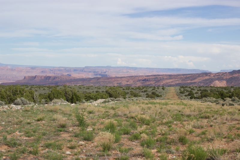
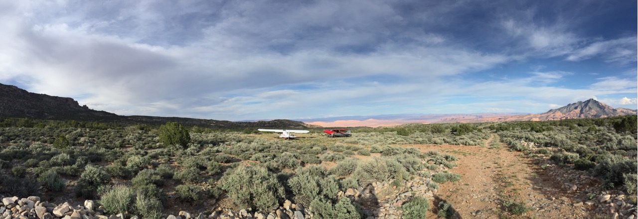
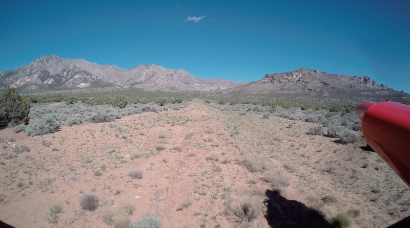
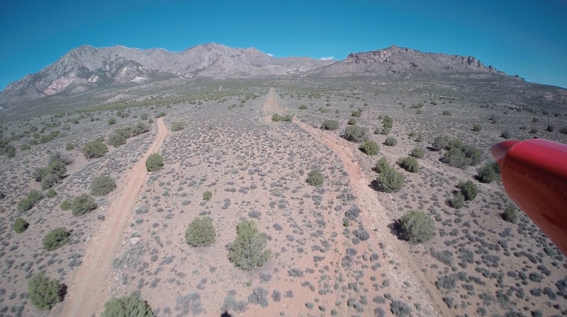
    Beautiful but rough airstrip on the east slopes of the Henry Mountains, UT. (see my PIREP)
    Primitive camping but developed campground about three miles away! Mostly Indian Sage and Juniper in the vicinity but there is an old miners camp with a little creek and lush oak trees just a quarter mile southeast of the lower RWY thresh hold. Water in the creek is flowing but we did not taste it.
    Lots of hiking an mountain biking possibilities!

    G.Himmeroeder May 1st, 2015

    Runway
    • Length

      3400

    • Width

      40

    • Surface

      GRAVEL/GRASS

    Details
    • Facility ID

      No ID 093

    • Elevation

      5808

    • CTAF

      122.9

    • State

      UT

    Gallery
    Location

    Lat: 37.87171554565 , Long: -110.61993408203 - UTAH, USA

    Get Directions
    Categories
    • Recreational
    Tags
    • Mountains
    Region
    • Northwest Mountain
    Ownership
    • Public
    Author
    shortfield
    mood_bad
  • No comments yet.
  • Add a review

    Leave a Reply · Cancel reply

    You must be logged in to post a comment.

    Related Videos
    Prev 1 of 73 Next
    • Flying around Moab, UT

      Flying around Moab, UT

      Went to Moab in March 2016 for a weekend and got to do some flying.
    • Missing 3 year old Drone Search Aneth UT South of residence along creek

      Missing 3 year old Drone Search Aneth UT South of residence along creek

      This video is about Missing 3 year old Drone Search Aneth UT South of residence along creek
    • nokai_dome.wmv

      nokai_dome.wmv

      In November 2009, I flew to Monument Valley with my flying buddies Paul and Mike. We continued on for 3 days of flying and two nights of camping at Utah backcountry airstrips strips. The first was Nokai Dome, on a rise overlooking the San Juan River and Lake Powell.
    • Departing 8,150ft Runway 22 at Walden, CO (33V) over North Platte River

      Departing 8,150ft Runway 22 at Walden, CO (33V) over North Platte River

      Departing Runway 22 Walden, CO (33V) over North Platte River in the North Park Valley. Runway is 8,150 feet!
    • Hidden Splender Utah

      Hidden Splender Utah

      An approach to Hidden Splendor in Utah. The landing strip was too soaked and soft to make a landing. Just what one would expect. Flying out from the Chicago area to a desert in Utah and find that you can't land....
    • Farmers Feeding Utah Navajo's Project

      Farmers Feeding Utah Navajo's Project

      This event took place on May 25th, 2020 during Memorial Day Weekend. This was coordinated along with Rebecca Benally and my little brother got drone footage and I edited the video.
    • Flying into Salt Lake City Utah

      Flying into Salt Lake City Utah

    • Abandoned Smelter

      Abandoned Smelter

      This is a concrete ruin above warm springs near santaquin utah. It was used to process ore that came from the mines a Dividend utah. There is warm springs below, but they have been closed by the utah DWR. Trespassing is not recommended its a $500 fine.
    • Hidden Treasure - The Lost Rhoades Mine

      Hidden Treasure - The Lost Rhoades Mine

      http://www.CenterstarMarketing.com

      One of the most exciting stories of lost treasure comes from the early days of the Mormon settlers in Utah. If you have ever been to Salt Lake City, the most impressive site is the Mormon Temple. On the very top of the temple is a statue of the angel, Moroni. The statue is covered with solid gold. According to Mormon legend the gold was provided by Thomas Rhoads, from mines known only to him and then lost forever in the Utah back country.

      PLEASE SUBSCRIBE!
    • Landing at Hooper, CO (PVT) for a dip in the Sand Dunes Pool (HD)

      Landing at Hooper, CO (PVT) for a dip in the Sand Dunes Pool (HD)

      This is a very cool place to visit if you get a chance. The airstrip is located on private property and you must call in advance to get permission. The Sand Dunes pool exceeded my expectations and the atmosphere, pool, service, food is terrific! Must see!

      The airstrip is hard packed and fairly smooth, parking is located at the far west end near the road. DO NOT land on the airstrip without permission and if farmers are working in the field.

      Shot with Drift HD170 Stealth available at www.MyPOV360.com
    • Montezuma Canyon

      Montezuma Canyon

      Our trip down Montezuma Creek Road. I give a very brief history of the native americans that lived in the area. We see many petroglyphs and several dwelings as well as a spiritual Kiva.

      A History of San Juan County. In the Palmof Time by Robert S. McPherson
      https://digitallibrary.utah.gov/awweb/awarchive?type=file&item=34354

      Jeep The USA Montezuma Creek trail.
      https://www.jeeptheusa.com/montezuma-creek-gp.html
    • Flying Utah's Dirt Strips 5-6-11

      Flying Utah's Dirt Strips 5-6-11

      A flight of 2 Kitfox's flying Utah Dirt airstrips.
    Prev 1 of 73 Next

    You May Also Be Interested In

    STARR SPRING, UT

    • 37.82049942017, -110.63946533203
    • Recreational

    TRACHYTE RANCH, UT

    • 37.97103300000, -110.61295000000
    • Restricted

    SLATE CREEK, UT

    • 37.98519897461, -110.65111541748
    • Recreational

    © 2000-2021 shortfield.com

    Cart

      • Featured
      • Recreational
      • Restricted
      • Off-Airport
      • Abandoned
      • Outpost
      • Facebook
      • Twitter
      • WhatsApp
      • Telegram
      • LinkedIn
      • Tumblr
      • VKontakte
      • Mail
      • Copy link