Sign in or Register
    • Featured
    • Recreational
    • Restricted
    • Off-Airport
    • Abandoned
    • Outpost
    • Home
    • Explore
    • Shop

    Darwin Airstrip, CA

    • Overview
    • Reviews / PIREPs 0
    • Events
    • Videos
    • prev
    • next
    • Bookmark
    • Share
    • Leave a Review / PIREP
    • Report
    • prev
    • next
    Description

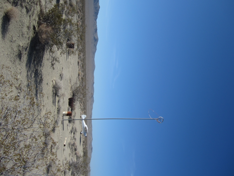
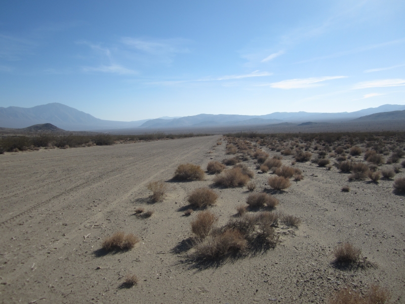
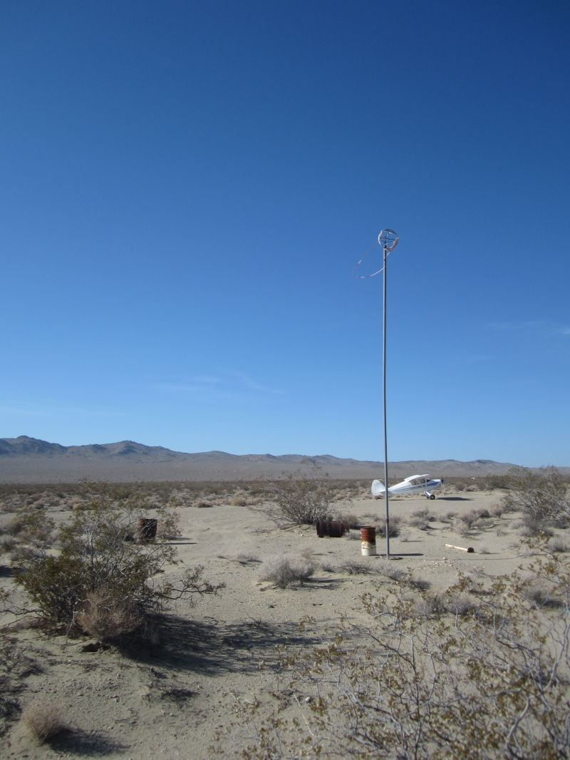
    The dirt and gravel strip is in good condition.  A windsock is on the north end but the desert sun and wind has deteriorated it to the point of being unusable.  There is a gradual uphill grade to the north and power lines on that end.  I did not find tiedowns on the north end but there is an open area too park.

    This strip is on BLM property and is open to the public for use.

    Runway
    • Length

      2300

    • Width

      75

    • Surface

      DIRT

    Details
    • Facility ID

      No ID 192

    • Elevation

      4118

    • CTAF

      122.9

    • State

      CA

    Gallery
    Location

    Lat: 36.26559886882 , Long: -117.59637218290 - , USA

    Get Directions
    Categories
    • Recreational
    Tags
    • Mountains
    • Desert
    Region
    • Western Pacific
    Ownership
    • Public
    Author
    shortfield
    mood_bad
  • No comments yet.
  • Add a review

    Leave a Reply · Cancel reply

    You must be logged in to post a comment.

    YouTube Search
    Prev 1 of 376 Next
    • Exploring 10 Abandoned Military Bases of CALIFORNIA

      Exploring 10 Abandoned Military Bases of CALIFORNIA

      Today we will be exploring all abandoned California military forts, bases and airfields.

      Are you fascinated by the forgotten stories of ghost towns and abandoned villages? Join us as we explore the eerie remains of once thriving communities and uncover their rich history. From deserted streets to crumbling architecture, these abandoned places hold so much mystery and intrigue. Don't miss out on this journey through time, hit that subscribe button now!

      00:00 Intro
      00:19 Castle Air Force Base, Merced County
      01:37 Alameda Naval Air Station, Alameda
      03:13 Mare Island Naval Shipyard, Vallejo
      04:34 Mare Island Naval Shipyard, Vallejo
      06:06 Presidio of San Francisco
      07:42 Hamilton Air Force Base, Novato
      09:26 Moffet Field, Mountain View
      11:02 McClellan Air Force Base, North Highlands
      12:19 Fort Ord, Monterey Bay Coast
      14:15 Naval Training Center, San Diego


      Abandoned military base in California, USA

      #GhostTowns #AbandonedVillages #ExploringTheForgotten #History #Mystery #america #abandoned #militarybase

      Make sure to turn on notifications so you never miss an episode of "Exploring the Forgotten." Share this video with your friends who love uncovering forgotten places and history. Let's dive into the past and uncover the secrets of ghost towns and abandoned villages together!
    • Exploring the ABANDONED George Air Force Base

      Exploring the ABANDONED George Air Force Base

      Support OUR adventures securely with PATREON:
      https://www.patreon.com/oddityodysseys

      Over 250 military buildings sit abandoned and decaying in a secluded and desolate corner of Victorville, California.
      Written by: Bethany Guerrero
      Cinematography and Visual Effects by: C. Drew Unser

      #abandoned #airforcebase #urbanexplorers

      CAMERA GEAR AND SETUP (AMAZON AFFILIATE LINKS)
      GoPro HERO9: https://amzn.to/3FizsTQ
      Stabilizer: https://amzn.to/3FlKkAp
      Zoom Audio Recorder: https://amzn.to/3vOBIPu
      Wireless Mic Packs: https://amzn.to/3MUP2HQ
      Mavic Drone: https://amzn.to/3kMnhFo
      360 Camera: https://amzn.to/3KPoMxk
      Panasonic Mirrorless Camera: https://amzn.to/3Fia2pm
      Lumix Lens: https://amzn.to/3FlQRev


      Web: www.oddityodysseys.com
      Instagram►https://www.instagram.com/oddityodysseys/
      TikTok►https://www.tiktok.com/@oddityodysseys

      Information Sources:
      http://www.themilitarystandard.com/afb/ca/george.php

      https://www.atlasobscura.com/places/george-air-force-base

      https://www.abandonedspaces.com/public/george-air-force-base-in-california.html?chrome=1&A1c=1

      Images Sources:

      https://www.pinterest.com/pin/121175046198125844/

      https://www.worthpoint.com/worthopedia/vintage-postcard-george-air-force-3765633514

      https://www.pinterest.com/pin/george-airforce-base-was-first-know-as-images-of-america-victorville--121175046198317772/

      https://en.wikipedia.org/wiki/George_Air_Force_Base

      Music by: incompetech.com and freepd.com

      "Babylon", "Witch Hunt", "Symmetry", and "Funkorama" by Kevin MacLeod (https://incompetech.com)
      License: CC BY (http://creativecommons.org/licenses/by/4.0/)

      Textures by: startextures.com
      Fonts by: fontsquirrel.com
    • Minietta Mine Airstrip

      Minietta Mine Airstrip

      A unique landing spot in the Panamint Valley of California. Many neat mining ruins in the surrounding hills including the well known Lookout City within hiking distance.
    • Hidden Airfield Near Garlock, California

      Hidden Airfield Near Garlock, California

      A video tour of an isolated dry lake in the Mojave desert near Garlock, California, which was supposedly used shortly after Pearl Harbor as a hiding place for fighter aircraft based at Muroc Army Airfield (now Edwards AFB), and Naval Air Station China Lake. However, after a tour of the place, I have my doubts. Terrain clearance (or lack of it, I mean), the short length of the runway (about 3100 feet), two deep depressions in the runway, its unusability during the rainy season, lack of parking space, no means of revetting aircraft or storing fuel and munitions, all point to the fact that this area would have been rather undesirable as an airport. Even if that had been its intended use, placing aircraft here would have had to be an act of near desperation, to be done only in the event the Japanese army was encroaching on the military airfields in the area. In my opinion, pierced steel plating would not have worked in the rainy season here, due to the sheer depth and extremely low bearing strength of the wet silt of this lakebed. Even had the runway been paved, it would, in my opinion, have been under water and therefore unusable. However, the BLM naturalist at Jawbone Station was adamant that this area had, in fact, been used as a hiding place for fighter aircraft based in the area. I don't know what to think. If you have any information on this area, please feel free to post it here on YouTube or e-mail me at mojaveroads@live.com.
    • Wyoming Ranch For Sale - Diamond G Ranch

      Wyoming Ranch For Sale - Diamond G Ranch

      Looking for a Wyoming Ranch For Sale? Arguably the finest mountain ranch retreat in the Rocky Mountain West. Diamond G doesn’t just claim to have it all. It, in fact, does! Privacy – It lies at the end of the road, virtually surrounded by state and federal lands. Access – It is accessible year-round and lies about 17 miles from Dubois and about one hour and 15 minutes from the Jackson Hole Airport. Fishing – It has an estimated 5 miles of the Dunoir River on private land with immediate access to 2.5 more miles on public land that is rarely accessed by the public. The Dunoir is a world-class trout fishery with trout in the 20 plus inch category. Wildlife – Bear, elk, moose, antelope, mountain lion, coyote, wolverine, multiple bird species, and both bighorn sheep and mountain goats are often seen in the adjacent national forest. It is one of the richest, wildest places for wildlife we have ever seen.

      https://hallhall.com/property-for-sale/wyoming/diamond-g-ranch/a095d00002M1c6j/

      Scenery – Absolutely breathtaking with a lush riparian corridor flanked by timbered and open mountains rising to over 11,000 feet topped by dramatic rock formations and three major peaks – Ramshorn, Coffin Butte and Pinnacles. Improvements – Comfortable lodge and guest quarters, operating facilities, and staff quarters all in an authentic western vernacular. Containing over 5,000 deeded acres - This is not just a small inholding in the national forest. When you come up the private road and see the ranch laid out before you, it is the real deal. There is virtually nothing else that one would want to own.

      #ranchforsale #wyoming #hallandhall

      Facebook: https://www.facebook.com/HallandHall/
      Instagram: https://www.instagram.com/hall_and_hall/
      Website: https://hallhall.com/

      Wyoming Ranches and Farms Playlist: https://www.youtube.com/playlist?list=PLKWx-7zy7DlFFyaEDD0KMNBGWyxIZRASr

      Music License: MB014YD0GAETALV
    • F4U Corsair leaving Darwin airstrip Australia

      F4U Corsair leaving Darwin airstrip Australia

    Prev 1 of 376 Next

    You May Also Be Interested In

    Panamint Springs, CA

    The airstrip has resort within walking distance of the airstrip. They have a place you can eat or get some…
    • 36.33831971384, -117.46675692047
    • Recreational

    Olancha, CA

    Dirt strip just west of HWY 395
    • 36.25602636478, -117.99714766086
    • Recreational

    Cinder Cone DL, CA

    Hard pan
    • 35.9835487602, -117.90019116936
    • Off-Airport

    © 2000-2021 shortfield.com

    Cart

      • Featured
      • Recreational
      • Restricted
      • Off-Airport
      • Abandoned
      • Outpost
      • Facebook
      • Twitter
      • WhatsApp
      • Telegram
      • LinkedIn
      • Tumblr
      • VKontakte
      • Mail
      • Copy link