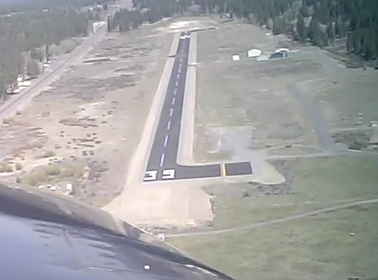
Sign in or Register
    • Featured
    • Recreational
    • Restricted
    • Off-Airport
    • Abandoned
    • Outpost
    • Home
    • Explore
    • Shop

    CHILOQUIN STATE, OR

    • Overview
    • Reviews / PIREPs 0
    • Events
    • Videos
    • prev
    • next
    • Bookmark
    • Share
    • Leave a Review / PIREP
    • Report
    • prev
    • next
    Description

    Chiloquin is a small airstrip north of Kalamath Falls. This airport is the closest paved strip to Crater Lake. The west ramp has three well maintained tie downs, and is across the street from a descent restaurant and a borderline motel. Both are called Melitas. The runway surface is very well maintained and the paint markings are bright. The runway is not plowed, and the airport is closed when snow is on the runway.

    Runway
    • Length

      3735

    • Width

      60

    • Surface

      ASPH-P

    Details
    • Facility ID

      2S7

    • Elevation

      4217

    • CTAF

      122.9

    • State

      OR

    Gallery
    Location

    Lat: 42.58319166667 , Long: -121.87612611111 - OREGON, USA

    Get Directions
    Categories
    • Recreational
    Tags
    • Mountains
    Region
    • Northwest Mountain
    Ownership
    • Public
    Author
    shortfield
    mood_bad
  • No comments yet.
  • Add a review

    Leave a Reply · Cancel reply

    You must be logged in to post a comment.

    Related Videos
    Prev 1 of 3 Next
    • Landing at Chiloquin in a Cessna Cardinal 177 RG

      Landing at Chiloquin in a Cessna Cardinal 177 RG

      Cessna Cardinal 177 RG Landing at Chiloquin State Airport, Chiloquin Oregon. This airport is on the 2012 Western Flight Tour. Check it out at http://www.WesternFt.com
    • B 25 Takeoff & Low Pass at Chiloquin Airport 2S7, Oregon, May 13, 2016

      B 25 Takeoff & Low Pass at Chiloquin Airport 2S7, Oregon, May 13, 2016

      It was VERY windy today, which helped taking off on this relatively-short Chiloquin runway. Stopping a B-25 is even MORE challenging, from what I've been told by the older pilots who flew them. Sony HDR-CX700V, edited in Final Cut Pro X and i7 iMac.
    • Prospect State Airport Oregon 64S

      Prospect State Airport Oregon 64S

      Prospect State Airport, Oregon (64S)
      In the foothills of the Cascades. Rogue River on the west side of town. Hike to Mill & Barr Creek Falls and Pearsony Falls. Avenue of Boulders view of the Rogue River. Walk to Prospect Cafe.
    • Crater Lake

      Crater Lake

      Short clip flying by Crater Lake and landing at Chiloquin State Airport (2S7)
    • Condon State Pauling Field Airport (3S9) Landing Rwy 25

      Condon State Pauling Field Airport (3S9) Landing Rwy 25

      Eleveation 2911 ft. / 887.3 m Rwy Dimensions: 3500 x 60 ft. / 1067 x 18 m
      http://www.airnav.com/airport/3s9
    • Landing at Independance State Airport

      Landing at Independance State Airport

      Arriving in Independance, OR (7S5) in a Cessna 172N.
    • Oakridge State Airport (5S0) Landing Rwy 27

      Oakridge State Airport (5S0) Landing Rwy 27

      Elevation: 1393 ft. / 425 m Rwy Dimensions: 3610 x 47 ft. / 1100 x 14 m
    • Skycatcher Landing at Freeway (W00)

      Skycatcher Landing at Freeway (W00)

      Shot with GoPro
    • BigBird

      BigBird

      Big Bird landing at Eagle Air, Sisters, Oregon
    • B25 takeoff at brackett airport

      B25 takeoff at brackett airport

      Collings foundation's b25 takin off at brackett airport on April 20th 2017
    • Crescent Lake (5S2) Landiing and Takeoff

      Crescent Lake (5S2) Landiing and Takeoff

    • Christmas Valley Airport (62S) Landing Rwy 7

      Christmas Valley Airport (62S) Landing Rwy 7

      Elevation: 4317 ft. / 1315.8 m Rwy Dimensions: 5200 x 60 ft. / 1585 x 18 m
    Prev 1 of 3 Next

    You May Also Be Interested In

    BEAVER MARSH STATE, OR

    Beaver Marsh is an extremely low use state airport just west of HW97 in the town of Beaver Marsh. Surface is…
    • 43.12752777778, -121.80872222222
    • Recreational

    TOKETEE STATE, OR

    Toketee State Airport (FAA LID: 3S6), is a public airport located two miles (3.2 km) south of the small town…
    • 43.22344444444, -122.42116666667
    • Recreational

    SILVER LAKE F S STRIP, OR

    No particular reason to go here except to do it.  Absolutely no facilities or trees and about 3 miles…
    • 43.11097250000, -121.09416666667
    • Recreational

    © 2000-2021 shortfield.com

    Cart

      • Featured
      • Recreational
      • Restricted
      • Off-Airport
      • Abandoned
      • Outpost
      • Facebook
      • Twitter
      • WhatsApp
      • Telegram
      • LinkedIn
      • Tumblr
      • VKontakte
      • Mail
      • Copy link