Description
Location Overview
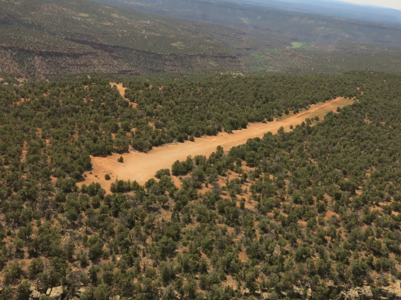
Calamity Mesa sits at an elevation of 6,650 feet in the high desert country southwest of Grand Junction, Colorado. It is accessible from Grand Junction via U.S. Highway 50 south, then State Highway 141 west toward Gateway, turning off at Niche Road and following it 16 miles to Calamity Mesa. The mesa top offers sweeping views of Flat Top Mesa, the Dolores River corridor, and Sewemup Mesa — dramatic canyon country that is, as one visitor put it, "mighty easy on the eye."
Camping & Recreation
Dispersed primitive camping is available near the airstrip on BLM land, and pilot reports note that the camping area looks great. The surrounding Grand Junction BLM lands offer an array of recreational opportunities including hiking, horseback riding, rafting, OHV riding, and mountain biking. The area also serves as a trailhead for the challenging 20-mile Calamity Mesa Loop, a 4WD route popular with well-equipped off-road vehicles, though its rough terrain keeps most ATV traffic away, preserving a quiet, remote atmosphere.
Notes & Warnings
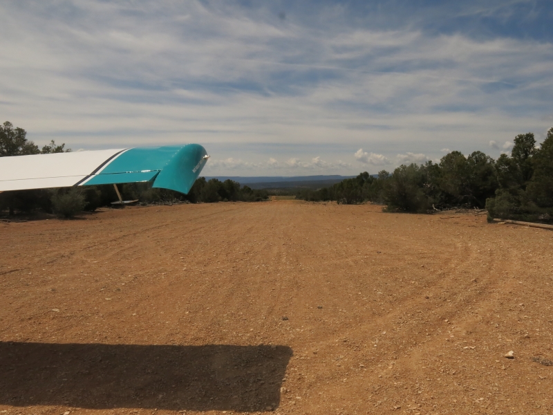
The runway is oriented 18/36, with a usable length of approximately 1,529 feet. Runway 36 is uphill with the first 140 feet unusable, and Runway 18 is downhill. Pilots should use caution for washouts on the east side of the airstrip, and may encounter vehicles, dirt bikes, and UTVs on or near the strip. It is also an active wildlife area with bears and mountain lions. Pilot reports note that the surface can become soft after rain or snow, with erosion ruts that are deeper than they appear in photos — particularly on the east side, though they can cross the centerline. Landing and staying on the west side of the strip is advisable when conditions are questionable. The common backcountry frequency is 122.9. Access by vehicle requires a very capable, well-equipped 4WD rig.
History
Calamity Mesa's identity is deeply tied to the uranium mining era of the Colorado Plateau. The nearby Calamity Camp is a well-preserved example of the historic mining camps that were active during the uranium booms spanning from 1916 to 1980, with several structures including a cookhouse still standing on site. The airstrip itself was likely developed to support access to this remote mining country, and old uranium mine shafts still dot the surrounding mesa — many tucked along cliff faces and barely visible from the road. In more recent times, the Calamity Mesa Loop road was reopened by local off-road enthusiasts, and the airstrip has attracted growing attention from the backcountry aviation community. As recently as 2021, the Recreational Aviation Foundation raised alarms about the potential closure of Calamity Camp Airstrip, along with several other nearby Colorado backcountry strips, due to a BLM resource management plan revision under consideration by the Grand Junction Field Office. Advocates successfully pushed for the strip's continued inclusion in travel management plans, keeping it open for recreational aviators.
Runway
-
Length
1500
-
Width
40
-
Surface
DIRT
Details
-
Elevation
6610
-
CTAF
122.9
Gallery
Location
Lat: 38.591056 , Long: -108.859625 - Colorado, USA


Add a review