Sign in or Register
    • Featured
    • Recreational
    • Restricted
    • Off-Airport
    • Abandoned
    • Outpost
    • Home
    • Explore
    • Shop

    TOKETEE STATE, OR

    • Overview
    • Reviews / PIREPs 0
    • Events
    • Videos
    • prev
    • next
    • Bookmark
    • Share
    • Leave a Review / PIREP
    • Report
    • prev
    • next
    Description

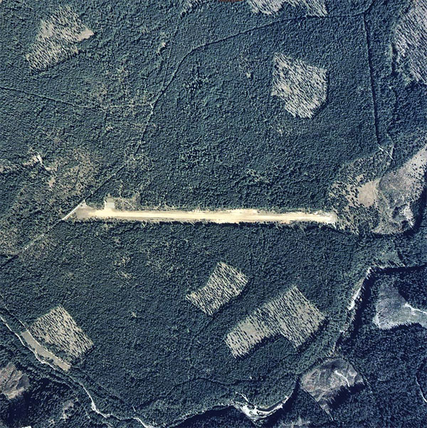
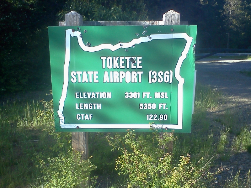
    Toketee State Airport (FAA LID: 3S6), is a public airport located two miles (3.2 km) south of the small town of Clearwater in Douglas County, Oregon in the Umpqua National Forest

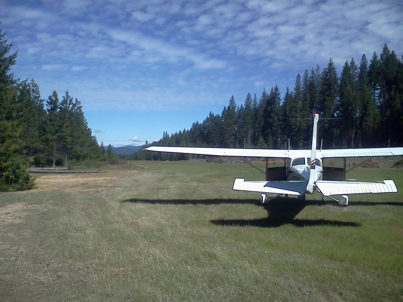
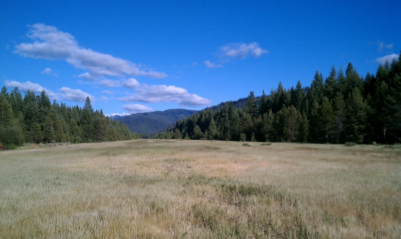
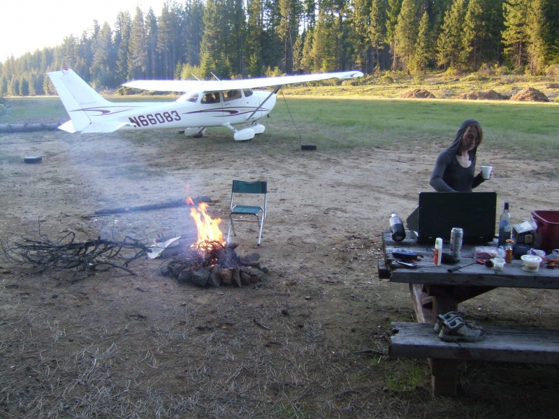
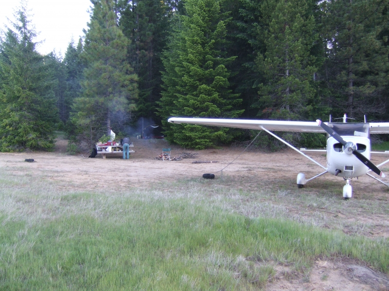
    Airport camping is permitted. The best camping is located on the east end. There are three tie-downs there, a picnic table and a fire ring. Also this is where the airport register is located. There is a faint trail behind the campsites that leads down to Fish Creek to the southeast. Camping on the east end you are over a mile from the nearest road. There is a pit toilet and the state airport sign located on the west end, this is where the road access is but access to the runway is gated. Fish Creek is open to trout fishing April 28th through October 31st. Due to numerous elk grazing on the runway the middle portion is currently pretty rough but the first 1500' or so of each end is pretty smooth. Watch for turkey and elk on the runway.

    Runway
    • Length

      5350

    • Width

      60

    • Surface

      TURF-F

    Details
    • Facility ID

      3S6

    • Elevation

      3361

    • CTAF

      122.9

    • State

      OR

    Gallery
    Location

    Lat: 43.22344444444 , Long: -122.42116666667 - OREGON, USA

    Get Directions
    Categories
    • Recreational
    Tags
    • Mountains
    Region
    • Northwest Mountain
    Ownership
    • Public
    Author
    shortfield
    mood_bad
  • No comments yet.
  • Add a review

    Leave a Reply · Cancel reply

    You must be logged in to post a comment.

    YouTube Search
    Prev 1 of 16 Next
    • Toketee State Airstrip - Maule M7-260C

      Toketee State Airstrip - Maule M7-260C

      My passenger could hold it no more - fortunately rough elk-trodden grass strips are not a problem for the Maule. This is a USFS airstrip that is open to the public after May 1st. Toketee Falls and the North Umpqua MTB trail is not far away from here but you need to be in real good shape to do the latter. Takeoff performance was a bit lacking this time - in retrospect there was a light tailwind in addition to long grass, density altitude, and heavier loading.
    • Willamette River and Toketee State (3S6) Oregon

      Willamette River and Toketee State (3S6) Oregon

      Having coffee by the Willamette River and Roasting
      Beer Dogs at Toketee State Oregon
    • Up and Out - Toketee State Airport, Oregon

      Up and Out - Toketee State Airport, Oregon

      Cessna 172N departing Toketee State on a warm summer afternoon. Field elevation 3361', density altitude 6000'. No wind. POH says we're up and out in 2115'... takes a bit longer due to grass field.
    • Finally a quiet night camping... at an airport - Always Ants

      Finally a quiet night camping... at an airport - Always Ants

      Join me and the (sleeping) ants at the Toketee State Airport (or Toketee Airstrip) in the Cascades of Oregon to enjoy the first quiet night and morning camping I'd had in weeks. Everywhere I camp, whenever there are other campers, they make far more noise than I can tolerate. From constantly running generators to problem barking dogs and of course the blasting stereos with full bass and the screaming children, no campground I've stayed in with other campers has offered the outdoors/nature experience one looks for when "getting away from it all" in the woods.
      Finally, and paradoxically, I found this little campsite beside the grass airstrip, and other than gradually encroaching creeps roaming the woods, I was undisturbed and unmolested. Can't say the locals camping out nearby were friendly or welcoming; their hostile looks and increasing frequency of drive-bys as well as coming closer and closer on foot made me rightly concerned for my safety. I would not recommend staying there alone. It was, however, a stunningly quiet morning, and being so cold, was ant-free for the moment. They were everywhere though, so unfortunately at the airstrip there are, as always, ants.
    • Fun At The Airstrip

      Fun At The Airstrip

      This is a movie I created from footage I shot at our friends' house last summer. They have a grass airstrip in their front yard! It was a blast.

      I created the movie using Magisto.
    • Chinese Street Fashion - [35] - Fashion China

      Chinese Street Fashion - [35] - Fashion China

      Hello Beautiful people around the world, Welcome to the China Fashion.
      Enjoy the video ๐Ÿ˜Š Chine Fashion Latest
      Donโ€™t forget to like, comment, and subscribe! Because your support is my spirit to make more videos.
      ๐Ÿ‘

      Song: Diviners - Savannah (feat. Philly K) [NCS Release]
      Music provided by NoCopyrightSounds
      Free Download/Stream: http://ncs.io/savannah
      Watch: http://youtu.be/u1I9ITfzqFs

      #chinafashion #latestfashionchina #chinesefashion
    Prev 1 of 16 Next

    You May Also Be Interested In

    BEAVER MARSH STATE, OR

    Beaver Marsh is an extremely low use state airport just west of HW97 in the town of Beaver Marsh. Surface is…
    • 43.12752777778, -121.80872222222
    • Recreational

    OAKRIDGE STATE, OR

    Oakridge State Airport is a well maintained state airport located on a bluff overlooking the town of…
    • 43.75255555556, -122.50452777778
    • Recreational

    GEORGE FELT, OR

    Nice strip for grass practice. Landed here 12-13-11 and it was in great shape.
    • 43.21544444444, -123.40438888889
    • Recreational

    ยฉ 2000-2021 shortfield.com

    Cart

      • Featured
      • Recreational
      • Restricted
      • Off-Airport
      • Abandoned
      • Outpost
      • Facebook
      • Twitter
      • WhatsApp
      • Telegram
      • LinkedIn
      • Tumblr
      • VKontakte
      • Mail
      • Copy link