Sign in or Register
    • Featured
    • Recreational
    • Restricted
    • Off-Airport
    • Abandoned
    • Outpost
    • Home
    • Explore
    • Shop

    OAKRIDGE STATE, OR

    • Overview
    • Reviews / PIREPs 0
    • Events
    • Videos
    • prev
    • next
    • Bookmark
    • Share
    • Leave a Review / PIREP
    • Report
    • prev
    • next
    Description

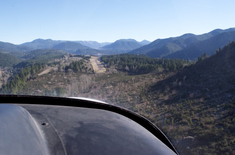
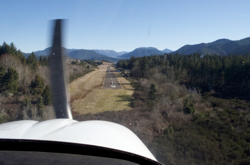
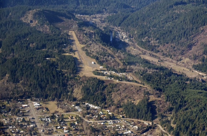
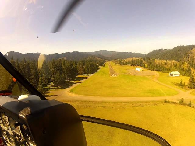
    Oakridge State Airport is a well maintained state airport located on a bluff overlooking the town of Oakridge. The runway is 3610x47', and is well-maintained. The runway dips in the center, causing a slight optical illusion on final. On approach to runway 09, there is a peak to the right of final, and a slope toward the threshold. There is also a small clump of trees off the approach end of runway 09. It was necessary for me to use an angled final, and turn once past the trees. Very similar to Toledo State. There aren't any parallel taxiways, and the only entrance/exit to the runway is near the approach-end of runway 27. Though the approach is more sporting, runway 9 is more efficient to arrivals, and 27 for departures, assuming calm wind. The ramp is in fair condition, with several tie-downs and a port-a-potty. It's not clear that there is any efficient means to get into town from the airport.

    Runway
    • Length

      3610

    • Width

      47

    • Surface

      ASPH-F

    Details
    • Facility ID

      5S0

    • Elevation

      1393

    • CTAF

      122.9

    • State

      OR

    Gallery
    Location

    Lat: 43.75255555556 , Long: -122.50452777778 - OREGON, USA

    Get Directions
    Categories
    • Recreational
    Tags
    • Trees
    Region
    • Northwest Mountain
    Ownership
    • Public
    Author
    shortfield
    mood_bad
  • No comments yet.
  • Add a review

    Leave a Reply · Cancel reply

    You must be logged in to post a comment.

    Related Videos
    Prev 1 of 20 Next
    • Oakridge State Airport (5S0) Landing Rwy 27

      Oakridge State Airport (5S0) Landing Rwy 27

      Elevation: 1393 ft. / 425 m Rwy Dimensions: 3610 x 47 ft. / 1100 x 14 m
    • Arrival and Departure from 5S5. Lake Billy Chinook State Airport Oregon

      Arrival and Departure from 5S5. Lake Billy Chinook State Airport Oregon

    • Landing at McKenzie Bridge airport 00S

      Landing at McKenzie Bridge airport 00S

      Landing at the McKenzie Bridge state airport, on the McKenzie river in Oregon.
    • Toledo_Landing.AVI

      Toledo_Landing.AVI

      Cessna 150 landing at Toledo State Airport, Oregon (5S4)
    • Bills takeoff from McKenzie Bridge state airport

      Bills takeoff from McKenzie Bridge state airport

    • Landing at Independance State Airport

      Landing at Independance State Airport

      Arriving in Independance, OR (7S5) in a Cessna 172N.
    • McKenzie Bridge 00S.mov

      McKenzie Bridge 00S.mov

      McKenzie Bridge Airport (00S)
    • Landing at Mcnary Field

      Landing at Mcnary Field

      November 28, 2010
    • Prospect State Airport Oregon 64S

      Prospect State Airport Oregon 64S

      Prospect State Airport, Oregon (64S)
      In the foothills of the Cascades. Rogue River on the west side of town. Hike to Mill & Barr Creek Falls and Pearsony Falls. Avenue of Boulders view of the Rogue River. Walk to Prospect Cafe.
    • Wakonda beach State Airport , Oregon (R33)

      Wakonda beach State Airport , Oregon (R33)

      A review of the Wakonda Beach State Airport, Oregon Coast (R33).
      This is a 2000 X 30 feet, grass airport.
      It is a more demanding airport and, good review of the comments and, remarks, is highly recommended.
      This airport will challenge your short, soft field techniques but, is quite rewarding as well.
      Happy Flying.

      P.S.: I have mistakenly marked it as S33 but, it’s actually R33.
      Sorry.
    • Owyhee Reservoir State Airport, 4/3/2016

      Owyhee Reservoir State Airport, 4/3/2016

      We had a few days of beautiful weather, so we headed to SE Oregon. The strip at Owyhee Reservoir has been on my list for quite awhile. It's a little rough, but the scenery can't be beat.
    • Too much wind

      Too much wind

      Here's just a short, fun little video I shot a few months ago. The runway for our local airport was closed for a couple days while they were using high cranes to raise portions of the bypass into place. I thought this would be a good time to shoot some video of the progress of the bypass near the airport (where I normally can't fly). Unfortunately, the wind was just too strong. My handheld anemometer was showing sustained 19-20mph winds. Clearly, my drone was fighting too hard to get any useful video. Keep in mind, the gimbal keeps the camera level even when my aircraft is listing at about 45 degrees... That should give you an idea of how it was getting tossed around.
    Prev 1 of 20 Next

    You May Also Be Interested In

    MC KENZIE BRIDGE STATE, OR

    This strip is in good condition.  Land east, take off west.  Trees on west end require a slightly steeper…
    • 44.18155555556, -122.08555555556
    • Recreational

    TOKETEE STATE, OR

    Toketee State Airport (FAA LID: 3S6), is a public airport located two miles (3.2 km) south of the small town…
    • 43.22344444444, -122.42116666667
    • Recreational

    DANIELS FIELD, OR

    This is a private field that gets minimal use and has ultralights hangered on site.  I use it as a…
    • 44.27206833333, -123.06092194444
    • Restricted

    © 2000-2021 shortfield.com

    Cart

      • Featured
      • Recreational
      • Restricted
      • Off-Airport
      • Abandoned
      • Outpost
      • Facebook
      • Twitter
      • WhatsApp
      • Telegram
      • LinkedIn
      • Tumblr
      • VKontakte
      • Mail
      • Copy link