Walker Army Airfield, Walker KS - Part 1
Walker Army Airfield is an abandoned airfield located north of Interstate 70 in Ellis County, 3 miles northeast of Victoria, Kansas. Walker AAF is a very large airfield that today is completely abandoned. It consisting of three runways, taxiways and a large paved ramp area.
Contracts were negotiated on 26 August 1942, and construction got under way on September 14. Three concrete runways 150 feet in width were paved to a length of 8,000 feet and graded at each end another 1,000 feet so that by adding concrete paving at each end, runways 10,000 feet long would be available. Concrete taxiways 75 feet wide, as well as an apron 300 by 375 feet, were constructed. Originally only one hangar was built, but by the time of the field's inactivation five hangars were in use. Completion to the point of limited occupancy was accomplished within 79 days after negotiation of the contracts. The ground station, located to the north of the airfield, consisted of more than one hundred buildings, all intended to be temporary. Station buildings and streets were also constructed, the buildings consisting primarily of wood, tar paper, and non-masonry siding. The use of concrete and steel was limited because of the critical need elsewhere. Most buildings were hot and dusty in the summer and very cold in the winter. Water, sewer and electrical services were also constructed.
Real base activity began when the 852d Signal Corps Detachment, the 3d Weather Squadron, the 23d Airways Communications Squadron, the 2064th Ordnance Corps Detachment and a medical detachment were attached to the 500th Base Headquarters and Air Base Squadron for administration, rations, and quarters. Early in 1943 a guard squadron, a quartermaster company, and an airdrome squadron arrived.
By the middle of 1943 a still further expansion of mission was due at Walker. The field was scheduled to begin training B-29 crews for combat duty, and in about August 1943 the first B-29s were brought in. Walker was to function through the remaining active portion of its career within the training program of the 17th Bombardment Operational Training Wing, which had its headquarters at Sioux City Army Base.
The field's mission changed drastically in the middle of 1943 when the 17th Bombardment Operational Training Wing at Sioux City Army Airfield began training B-29 Superfortress crews at Walker. The airfield became one of the first B-29 training facilities in the country and soon one of the finest. B-29s were new planes at the time used for long-distance flying and bombing. Built by Boeing, these aircraft could fly up to 5,830 miles non-stop and reach 365 miles per hour. In 1944 a railroad spur was constructed to the field from the Union Pacific Railroad. It was used to bring in equipment and B-29 engines.
Walker AAF was also equipped with a photographic laboratory. Cameras were mounted onto guns during missions and the film had to be developed before class the next day. Until the end of World War II the number of crews trained at Walker AAF was steady.
From very humble beginnings, both the mission and the physical plant of Walker Army Air Field expanded considerably so that by August 31, 1944, a total of 5,936 personnel were stationed at the field. Compared to the original 1,000 occupancy, Walker AAF had grown almost sixfold in just a couple years.
On January 31, 1946, Walker was put on inactive status, and disposition of property became the major activity at the field. In December 1958 the government held an auction to sell the many acres of the former airfield. The airfield was apparently abandoned at some point between 1965 and 1968. Shortly after WWII, the Air Force leased the NE/SW runway for a study dealing with explosive cratering. The craters are still visible and vegetation and trees have voluntarily grown in the craters.
The land was again sold in 1991, and in 1992 government personnel and the new owners performed a walkover. It was determined there was still hazardous waste left behind from World War II. 30 and 50 caliber casings and bullets were found on the former target range at the north end of the site. Four transformers left over from the war were on the apron and the wartime sewage treatment system in the southwest part of the field was still present although inoperable. A landfill was found half a mile south of the north–south runway. In four 3-foot by 4-foot areas, pharmacy bottles, syringes, mess hall plates, shells, spark plugs, and other items were found.
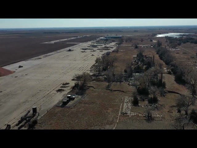
Today Walker AAF has the air of a ghost town. Almost all of the concrete airfield still exist, runways and taxiways in various states of deterioration, almost totally complete. Four hangars on the flight line area exist. Concrete foundations of the former base support buildings can be found, along with some of the road network. Outlines of the former streets are clearly visible in aerial photography.


Add a review