Description
Location Overview
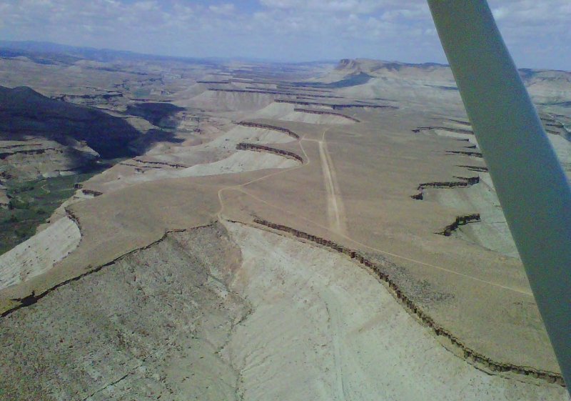
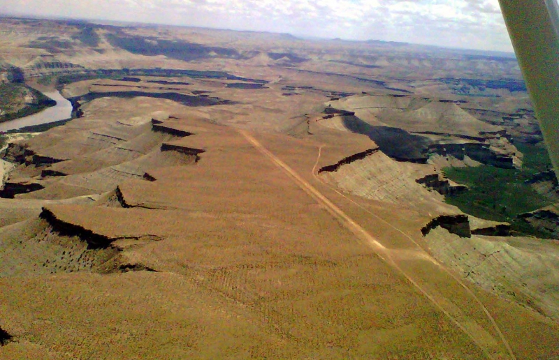
Sand Wash sits on a high mesa overlooking the Green River in the Tavaputs Plateau/Uinta Basin region of eastern Utah, at roughly 5,376 ft elevation. The single dirt runway (08/26) runs about 3,200 ft x 18 ft, with the east end privately owned and the remainder under BLM administration. It lies directly above the BLM's Sand Wash Ranger Station and Recreation Area, the official launch point for float trips through Desolation and Gray Canyons.
Camping & Recreation
The adjoining Sand Wash Recreation Area offers several primitive campsites plus four screened "bug huts" (cabins reservable through Recreation.gov), along with vault toilets, picnic tables, and fire rings — though there's no running water or trash service. It functions primarily as the put-in for the 84–96 mile Desolation/Gray Canyon Green River trip, part of a National Historic Landmark designated in 1969, with short hiking trails, side canyons, petroglyphs, and historic ranch sites nearby. River travel requires a BLM permit, and there's no cell service on site.
Notes & Warnings
This is a true backcountry strip: the first half of the runway is notably rocky and bumpy (pilot reports mention this even on tundra-tire aircraft), with the back half in better shape and Runway 26 sloping uphill slightly. Strong, variable canyon winds and challenging crosswinds are common on both landing and takeoff, and traffic spikes heavily in summer as river-runner shuttles and float-trip support flights come and go. As with any unimproved strip, current surface conditions should be verified before landing, and pilots should expect rough, narrow, and gusty conditions overall.
History
Long before it became a backcountry airstrip, Sand Wash was one of the only practical crossings of the Green River for hundreds of miles, with a ferry operated by the Stewart family from the 1920s through the 1950s; several of their homestead cabins still stand near the site. The surrounding canyon country, part of the rugged Tavaputs Plateau, was also frequented by outlaw gangs like the Wild Bunch and dotted with early 20th-century ranches such as Rock Creek Ranch. In 1969, the broader Desolation Canyon area was designated a National Historic Landmark to mark the centennial of John Wesley Powell's pioneering 1869 Green and Colorado River expedition. Today, Sand Wash's dual identity as both a BLM river put-in and a small dirt airstrip reflects its enduring role as a remote access point — once for ranchers and ferry travelers, now for river runners and backcountry pilots.
Runway
-
Length
3203
-
Width
35
-
Surface
DIRT
Details
-
Facility ID
No ID 113
-
Elevation
5402
-
CTAF
122.9
Gallery
Location
Lat: 39.830872, Long: -109.927258- UTAH, USA


Add a review