Sign in or Register
    • Featured
    • Recreational
    • Restricted
    • Off-Airport
    • Abandoned
    • Outpost
    • Home
    • Explore
    • Shop

    MARBLE, CO

    • Overview
    • Reviews / PIREPs 0
    • Events
    • Videos
    • prev
    • next
    • Bookmark
    • Share
    • Leave a Review / PIREP
    • Report
    • prev
    • next
    Description

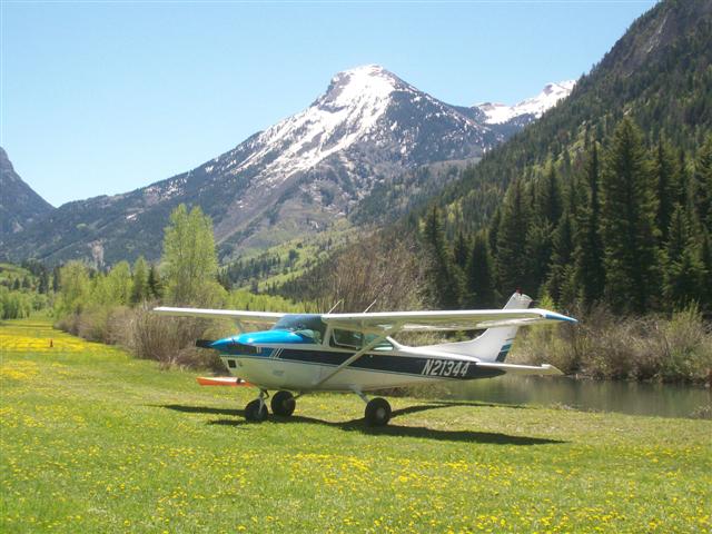
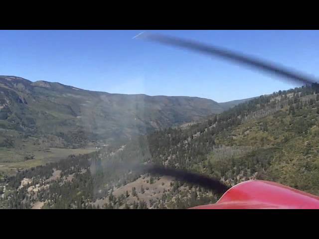
    This is a PRIVATE airstrip. Do NOT land without prior, written permission from the owners.  Nonstandard pattern--fly upwind, crosswind, and downwind at 9000' MSL--do not make a straight-in.  For nearly all aircraft this strip is one way: land to the east, t/o west.  Last 600 feet on the east end in poor condition.  More information at coloradopilots.org .

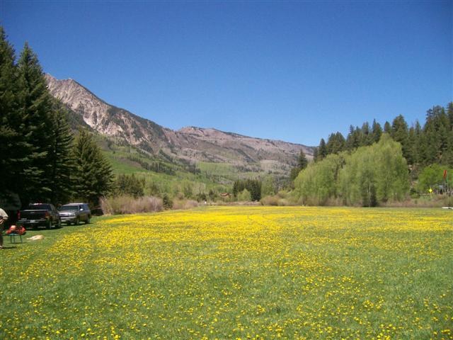
    For all practical purposes, this strip is less than 3800' long, measured from the road on the west to the marble stripe on the east. East of the stripe is only good for taxiing slowly and turning around. The first few hundred feet west of the road is rough. The main part of the strip is smooth enough that fat tires are not necessary--any standard aircraft tire is sufficient. Take care taxiing off the side to park, as there are some obstacles which can damage tires.

    Runway
    • Length

      4600

    • Width

      75

    • Surface

      TURF

    Details
    • Facility ID

      No ID 058

    • Elevation

      7812

    • CTAF

      122.9

    • State

      CO

    Gallery
    Location

    Lat: 39.07421100000 , Long: -107.21321600000 - COLORADO, USA

    Get Directions
    Categories
    • Restricted
    Tags
    • Mountains
    • Trees
    Region
    • Northwest Mountain
    Ownership
    • Private
    Author
    shortfield
    mood_bad
  • No comments yet.
  • Add a review

    Leave a Reply · Cancel reply

    You must be logged in to post a comment.

    YouTube Search
    Prev 1 of 166667 Next
    • Super Cub @ Marble, Colorado

      Super Cub @ Marble, Colorado

      Landing to the West, private airstrip at Marble, Colorado.
    • Marble Colorado Airstrip Flyby 79CAVV

      Marble Colorado Airstrip Flyby 79CAVV

      1st pass to the west; 2d pass to the east, which is the recommended approach landing up valley. Sound track was purchased for private use and is not for sale.
    • The Crystal Mill, Schofield Pass Marble Colorado #jeep #4x4 #offroad

      The Crystal Mill, Schofield Pass Marble Colorado #jeep #4x4 #offroad

      In this video, we visit the amazing Crystal Mill, and take our Jeep over the deadly Schofield Pass, located near Marble Colorado.
    • Marble.mpg

      Marble.mpg

      Approach and landing at Marble, Colorado backcountry airstrip
    • Landing at Marble, CO at annual Colorado Pilots Association camping fly-in

      Landing at Marble, CO at annual Colorado Pilots Association camping fly-in

      Landing at Marble, CO, mid September 2010, density altitude approximately 10,000'. 1963 Cessna P172D, converted to 180hp Lycoming, semi-STOL, pilot + Golden Retriever + camping equipment. The Marble strip is a private airstrip approximately 3800' long, in a canyon at 7800' elev., in west central Colorado roughly 30 miles south of Glenwood Springs and 25 miles southwest of Aspen.
    • Marble Colorado 2014

      Marble Colorado 2014

      The Crystal River Valley is among the top tourism attractions in the State of Colorado, located on the western slope of the Rocky Mountains, just a few miles south from the I-70 Hwy 82 exit at Glenwood Springs. This picturesque valley extends along Hwy 133, part of the West Elk Loop Scenic Byway, from Carbondale to Redstone, then County Road 3 to Marble and Crystal City.
    Prev 1 of 166667 Next

    You May Also Be Interested In

    Gunnison River Farms, CO

    Private Airstrip in support of the lodge and Black Canyon Anglers. Visit the following link for complete…
    • 38.78009026273, -107.90013650120
    • Recreational

    Moss Lake, CO

    Does anyone have information on this old Colorado airstrip?This abandoned airstrip is heavily overgrown with…
    • 38.27003455816, -106.73276836624
    • Recreational

    Quarter Circle Circle (BLM), CO

    BackCountry Airstrip with Cabin Rentals, Hunting, Horse rentals, Private fishing, is available from the…
    • 38.14276209603, -106.74626783832
    • Recreational

    © 2000-2021 shortfield.com

    Cart

      • Featured
      • Recreational
      • Restricted
      • Off-Airport
      • Abandoned
      • Outpost
      • Facebook
      • Twitter
      • WhatsApp
      • Telegram
      • LinkedIn
      • Tumblr
      • VKontakte
      • Mail
      • Copy link