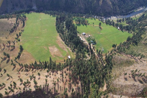
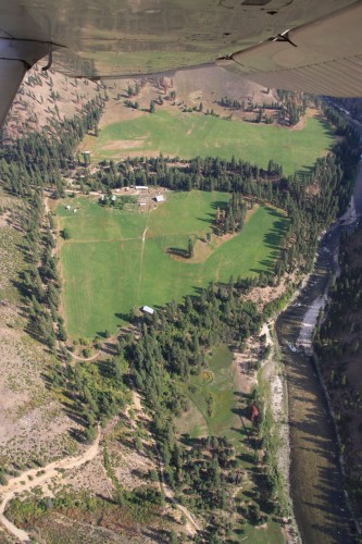
Sign in or Register
    • Featured
    • Recreational
    • Restricted
    • Off-Airport
    • Abandoned
    • Outpost
    • Home
    • Explore
    • Shop

    SOUTH FORK RANCH, ID

    • Overview
    • Reviews / PIREPs 0
    • Events
    • Videos
    • prev
    • next
    • Bookmark
    • Share
    • Leave a Review / PIREP
    • Report
    • prev
    • next
    Description

    This is a private ranch.  Do not land without prior permission from owners.

    Runway
    • Length

      ?

    • Width

      ?

    • Surface

      TURF

    Details
    • Facility ID

      No ID 157

    • Elevation

      ?

    • CTAF

      122.9

    • State

      ID

    Gallery
    Location

    Lat: 45.24360289290 , Long: -115.53203653903 - IDAHO, USA

    Get Directions
    Categories
    • Restricted
    Region
    • Northwest Mountain
    Ownership
    • Private
    Author
    shortfield
    mood_bad
  • No comments yet.
  • Add a review

    Leave a Reply · Cancel reply

    You must be logged in to post a comment.

    YouTube Search
    Prev 1 of 71 Next
    • Flying B Ranch, ID (12ID)

      Flying B Ranch, ID (12ID)

      Approach and landing at the Flying B airstrip (12ID) on the Middle Fork of the Salmon in Idaho
    • 2022 Idaho Backcountry Flying.  Many airstrips visited with tons of detailed info on each.

      2022 Idaho Backcountry Flying. Many airstrips visited with tons of detailed info on each.

      Idaho backcountry, truly an aviators paradise! Visited Johnson, Upper/Lower Loon, Thomas, Indian, Smiley, Krassel, Big Creek, Shearer, Fish, Moose, Cayuse. Five onboard cameras rolling to give you as much scenery as possible. Two GoPro Max 360 cameras allow for an "out of airplane" experience. This was a dream trip that we wanted to record for our own memory but hope we can entertain you to a degree as well...maybe even entice you to experience the same adventure yourself.
      A number of similar adventures on my channel, Rick Hiebert. Subscribe if you want to see more.
      Best viewed in 1080HD.

      Time stamps:
      01:57 Cowley WY (first night)
      02:59 Smiley Creek
      03:39 Johnson Creek (landing runway 35)
      07:46 Upper Loon Creek
      10:25 Lower Loon Creek
      12:22 Mahoney Creek
      12:43 Thomas Creek
      15:49 Indian Creek
      17:27 Johnson Creek
      20:08 Reed Ranch
      21:09 Krassel
      24:43 Big Creek
      27:22 Johnson Creek
      29:38 McCall (for fuel)
      30:32 Shearer
      33:02 Moose Creek
      35:07 Fish Lake
      36:26 Cayuse Creek
      38:14 Benchmark MT
      39:56 Chinese Wall, MT
      42:52 Gibson Reservoir & Dam
      44:53 Choteau MT (for fuel)
    • G&S landing at a private ranch, Chamberlain, ID

      G&S landing at a private ranch, Chamberlain, ID

      G&S Aviation delivers freight to a Private Ranch in Chamberlain Basin, ID. This airport , at 5,500 ft MSL, is only 1,000 long before an unusable dog leg occurs. Essentially, the dog leg gives you a survivable overrun, and that's all - if you aren't slowed down. This Ranch isn't open to public traffic, so please respect their property rights.
    • Idaho Backcountry Marble Creek Airstrip Cessna 185

      Idaho Backcountry Marble Creek Airstrip Cessna 185

      The newest backcountry airstrip in Idaho 🙏
    • Afton Man Accused Of Operating Private Airport Behind His Home

      Afton Man Accused Of Operating Private Airport Behind His Home

      Jeffrey Walker, 57, faces five misdemeanor counts in Washington County for violating the Afton’s restrictions for airstrips
    • Schafer Meadows Airstrip Project: 2020

      Schafer Meadows Airstrip Project: 2020

      Schafer Meadows is the last remaining active airstrip within a designated wilderness area in the state of Montana, located 14 miles from the nearest trailhead in the Bob Marshall Wilderness Complex. In 2020 the U.S. Forest Service began the work of restoring the historic airstrip using a team of mules and two vintage graders -- a process that had not been completed since the Great Bear Wilderness was designated in 1978.

      Find Part 2 with the work done in 2021 here: https://youtu.be/FiV9JCoQRHk

      Video provided by Fred and Nancy Flint.
    Prev 1 of 71 Next

    You May Also Be Interested In

    BARKELL RANCH, ID

    • 45.18888888889, -115.56694444444
    • Restricted

    YELLOW JACKET RANCH, ID

    • 45.15204904206, -115.56095623201
    • Restricted

    BADLEY RANCH, ID

    Private airstrip. Warning- photos posted here are not Badley, but Copenhaver nearby and downstream to the North.
    • 45.35817117705, -115.52088254832
    • Restricted

    © 2000-2021 shortfield.com

    Cart

      • Featured
      • Recreational
      • Restricted
      • Off-Airport
      • Abandoned
      • Outpost
      • Facebook
      • Twitter
      • WhatsApp
      • Telegram
      • LinkedIn
      • Tumblr
      • VKontakte
      • Mail
      • Copy link