Sign in or Register
    • Featured
    • Recreational
    • Restricted
    • Off-Airport
    • Abandoned
    • Outpost
    • Home
    • Explore
    • Shop

    PEACH STATE, GA

    • Overview
    • Reviews / PIREPs 0
    • Events
    • Videos
    • prev
    • next
    • Bookmark
    • Share
    • Leave a Review / PIREP
    • Report
    • prev
    • next
    Description


     Great little grass roots airport in the heart of central Georgia.  More information here:

    http://www.peachstateaero.com/dotnetnuke/tabid/165/Default.aspx 

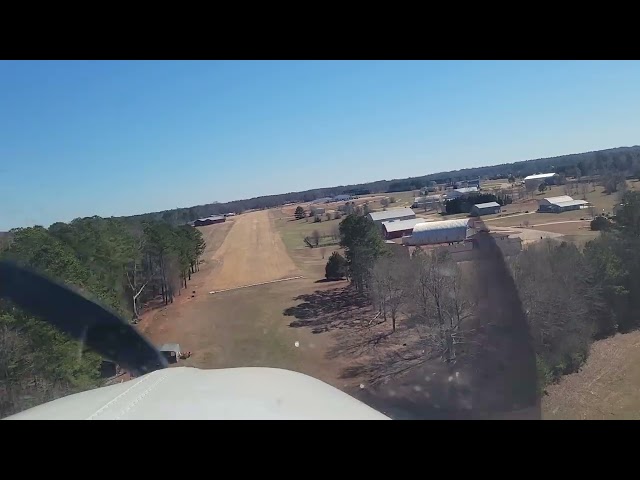
    The runway direction is 31 - 13.   Field Elevation 950 ft msl.  Traffic advisory on 122.8 - unmonitored.  Avgas is available.RUNWAY 13 OPERATIONS - right hand pattern - The runway has an uphill slope.   Caution - this slope must be taken into aircraft performance considerations when taking off on runway 13.  Given a high density altitude during warm weather along with the slope of the runway many small aircraft will be performance limited.  A right hand traffic pattern is used for landing on Runway 13.  RUNWAY 31 OPERATIONS - left hand pattern - The threshold is displaced.  Taking off prior to the marked threshold is not permitted because you can not see other aircraft that may be taking off the other way  The runway slopes downhill on Runway 31 increasing the landing roll of aircraft that land or rollout more than 1,000 ft from the threshold.  The landing approach is over trees that are approximately 50 ft in height.  A left hand traffic pattern is used for landing on runway 31.  When landing and departing please remain clear of all houses that are located in the area. 

    Flybys are permitted as long as the normal traffic pattern is used. No aerobatics within a 5 nautical mile radius of the airport. 

    Runway
    • Length

      2400

    • Width

      100

    • Surface

      TURF-F

    Details
    • Facility ID

      GA2

    • Elevation

      926

    • CTAF

      122.9

    • State

      GA

    Location

    Lat: 33.18345305556 , Long: -84.37159027778 - GEORGIA, USA

    Get Directions
    Categories
    • Recreational
    Tags
    • Trees
    Region
    • Southern
    Ownership
    • Public
    Author
    shortfield
    mood_bad
  • No comments yet.
  • Add a review

    Leave a Reply · Cancel reply

    You must be logged in to post a comment.

    YouTube Search
    Prev 1 of 25519 Next
    • 2023 04 15 Low Approach in a Cessna 150 over Peach State Aerodrome

      2023 04 15 Low Approach in a Cessna 150 over Peach State Aerodrome

    • Flying to Peach State Aerodrome in a Cessna 182 #aeroplane#aviation#airplane#hartzell top props#fly

      Flying to Peach State Aerodrome in a Cessna 182 #aeroplane#aviation#airplane#hartzell top props#fly

    • Bonanza landing at Peach State Aerodrome (GA2)

      Bonanza landing at Peach State Aerodrome (GA2)

      grass strip. Great food, crappy camera angle, my bad.
      A36 beachcraft bonanza
    • Landing at GA2 Peachstate Aerodrome

      Landing at GA2 Peachstate Aerodrome

      Landing at GA2 (Peachstate Aerodrome) for the "Offical Georgia Pilot's" inagural Fly-in.
    • Awesome vintage aircraft FLYBYS at the Peach State Aerodrome in Williamson, GA!

      Awesome vintage aircraft FLYBYS at the Peach State Aerodrome in Williamson, GA!

    • Peach State Aerodrome (May 5, 2022)

      Peach State Aerodrome (May 5, 2022)

      Peach State Aerodrome near Williamson, GA
    Prev 1 of 25519 Next

    You May Also Be Interested In

    MONTICELLO SKY RANCH, GA

    Smooth grass strip with great approach from South - over an open field.  Beware there IS a fence at the…
    • 33.33250000000, -83.72694444444
    • Restricted

    © 2000-2021 shortfield.com

    Cart

      • Featured
      • Recreational
      • Restricted
      • Off-Airport
      • Abandoned
      • Outpost
      • Facebook
      • Twitter
      • WhatsApp
      • Telegram
      • LinkedIn
      • Tumblr
      • VKontakte
      • Mail
      • Copy link