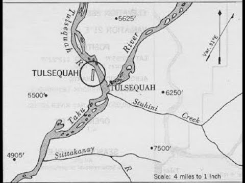
Sign in or Register
    • Featured
    • Recreational
    • Restricted
    • Off-Airport
    • Abandoned
    • Outpost
    • Home
    • Explore
    • Shop

    Tulsequah, BC - Canada

    • Overview
    • Reviews / PIREPs 0
    • Events
    • Videos
    • prev
    • next
    • Bookmark
    • Share
    • Leave a Review / PIREP
    • Report
    • prev
    • next
    Description

    abandoned mine site, condition unknown

    Runway
    • Length

      1500

    • Width

      50

    • Surface

      GRAVEL

    Details
    • Facility ID

      new

    • Elevation

      116

    • CTAF

      122.9

    • State

      BC - Canada

    Location

    Lat: 58.69818934346 , Long: -133.62908315660 - , USA

    Get Directions
    Categories
    • Recreational
    Tags
    • Mountains
    Region
    • Western Pacific
    Ownership
    • Public
    Author
    shortfield
    mood_bad
  • No comments yet.
  • Add a review

    Leave a Reply · Cancel reply

    You must be logged in to post a comment.

    YouTube Search
    Prev 1 of 3 Next
    • Randy Stagg Video Production, BC Airfield Stories, Tulsequah

      Randy Stagg Video Production, BC Airfield Stories, Tulsequah

      Tulsequah is an unincorporated locality in north-western, British Columbia, Canada, located at the confluence of the Taku and Tulsequah Rivers. The Tulsequah Chief Mine is located nearby, about ten miles up the Tulsequah River.
      Peterson Air Services of Atlin had operated a regular service to Tulsequah since 1950. By 1955 the airstrip was operated by Consolidated Mining and Smelting Co. Ltd. and had been lengthened to 2,800 feet by 150 feet. By the mid 1960’s there was no further reference to the strip in government publications. The B.C. Aviation Council air facilities map of 1975 again shows a strip at the site 2,000 feet long.
      Early 1950’s mining was done for oar and gold nuggets. However when it was no longer economical the mine was closed. Today a lot of Acid Mine Drainage including Barium, Cadmium, Lead, Zinc, Arsenic & other potential contaminates totalling Approx. 860,000 litters enter the river every day. In 1990 Redford Resources Ltd. wanted to reopen the mine and build a 100 mile long road into the area. The Nations Elders fought to stop the road and protect the environment. This ended up going to the Supreme Court who backed the first nation’s right to protect the land. In 2019 the federal government made an initial investment to protect and conserve the area. In 2000 a land guardian Program was established to provide jobs to manage the lands, monitor wildlife and keep track of the impact of industry in the area.

      Reference from video: “Our Land Is Our Future”. The Indigenous Leadership Initiative in partnership with the Taka River Tlingit First Nation
      https://diataku.com/portfolio-items/our-land-is-our-future/
      References:
      Chris Weicht is an accomplished 18,000 pilot and has chronicled the history of aviation in BC. He is the author of the book series "Air Pilot Navigator". Air Pilot Navigator, Volume 3: Air Route To The Klondike is where the story for this videos story can be found as part of the video series “British Columbia Airfield Stories”. Chris’s research included interviewing aviators and their next of kin who opened up their photo albums and often related exploits of flights creating some outstanding historical aviation books.
      If you would be interested in buying Chris Weicht’s books go to coasteaglepublications.com

      Special thanks Doug Rollins and Geoff Hallett Archival Photos for providing this material.
      Google Earth Pro
      Map Data 2022 Google
      Wikipedia
      Video:
      Skyvan SC-7 Landing Tulsequah
      xxx1847
      TULSEQUAH CHIEF
      Vanesa Bennett

      Linda R Stagg: Host / Script
      Chris Weicht: Author book series "Air Pilot Navigator"
      Geoff Hallett: Archival Files / BCAM Librarian
      Back Ground Music: “Smokie Part 1” by Bill Black Combo
      Randy Stagg: Video Production / Script

      youtube.com/@rvjs100

      Playlist: “BC Airfield Stories”
    • Mine Surveyors Helicopter Commute to Work

      Mine Surveyors Helicopter Commute to Work

      Mine Surveyors from Underhill Geomatics - http://underhill.ca/land-surveying-services/6/mining-and-tunneling -- commuting from Atlin, BC to Tulsequah Chief Mine, about 100 km south.

      The Tulsequah Chief Deposit is about 110 metres above sea level and the mine project encompasses approximately 14,220 hectares, in which there are 13 mineral claims.

      Read more about mining surveying undertaken by Underhill Geomatics:

      http://www.underhill.ca/land-survey-project/6/12/mining-and-tunneling/ruby-creek-mineral-lease-survey

      Underhill Geomatics Ltd.
      www.underhill.ca

      Vancouver
      Unit 210A - 3430 Brighton Ave.
      Burnaby, BC, V5A 3H4
      Canada
      Phone: 604-732-3384

      Kamloops
      204 - 153 Seymour St.
      Kamloops, BC V2C 2C7
      Canada
      Phone: 250-372-8835

      Whitehorse
      4081 - 4th Ave.
      Whitehorse, YT,Y1A 1H4
      Canada
      Phone: 867-668-2048
    • Tulsequah Chief's Feasibility Study Life of Mine schedule

      Tulsequah Chief's Feasibility Study Life of Mine schedule

      This video outlines the annual Life of Mine development and economics stope sequence to produce 6.4Mt of Ore Reserves.
    • Eskay Creek's Prefeasibility Study Highlights and Pathway to Production

      Eskay Creek's Prefeasibility Study Highlights and Pathway to Production

      Skeena Resources Limited is a Canadian mining exploration and development company focused on revitalizing the past-producing Eskay Creek gold-silver mine located in Tahltan Territory in the Golden Triangle of northwest British Columbia, Canada. The Company released a Prefeasibility Study for Eskay Creek in July 2021 which highlights an open-pit average grade of 4.57 g/t AuEq, an after-tax NPV5% of C$1.4B, 56% IRR, and a 1.4-year payback at US$1,550/oz Au. Skeena is currently completing both infill and exploration drilling to advance Eskay Creek to full Feasibility by Q1 2022. Additionally, the Company continues exploration programs at the past-producing Snip gold mine.

      The scientific and technical information in this video was approved by Paul Geddes, P.Geo., a Qualified person as defined under National Instrument 43-101 and Vice President, Exploration and Resource Development for the Company.
    • Gran Duc crash.mp4

      Gran Duc crash.mp4

      Voli di prova con GO Pro
    • granduc winter 2011.wmv

      granduc winter 2011.wmv

      takin a load up to the granduc mine site
    Prev 1 of 3 Next

    You May Also Be Interested In

    Telegraph Creek, BC - Canada

    removed from CFS in 2012 - not maintained but still well used, 1/2 hr walk into historic town on river…
    • 57.91406925563, -131.12565946583
    • Recreational

    © 2000-2021 shortfield.com

    Cart

      • Featured
      • Recreational
      • Restricted
      • Off-Airport
      • Abandoned
      • Outpost
      • Facebook
      • Twitter
      • WhatsApp
      • Telegram
      • LinkedIn
      • Tumblr
      • VKontakte
      • Mail
      • Copy link