Sign in or Register
    • Featured
    • Recreational
    • Restricted
    • Off-Airport
    • Abandoned
    • Outpost
    • Home
    • Explore
    • STOL Gear

    RED HILLS, CA

    • Overview
    • Reviews / PIREPs 1
    • Videos
    • Events
    • prev
    • next
    • Leave a Review / PIREP
    • Bookmark
    • Report
    • Share
    • prev
    • next
    Description

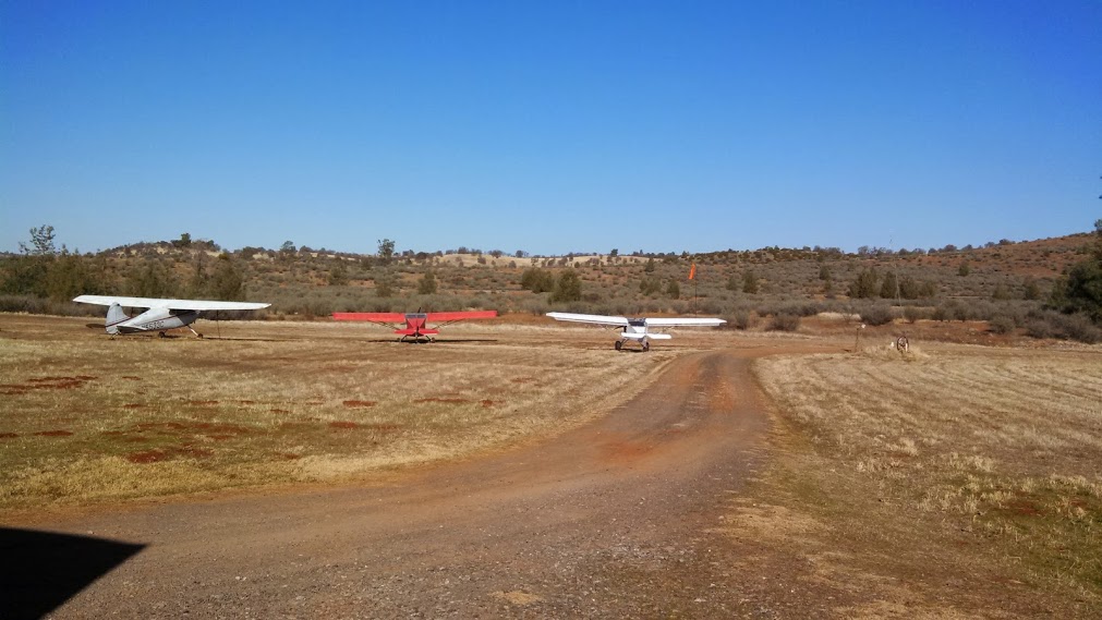
    Red Hills Strip is owned by Jack and Myrna Moyle. They are friendly welcoming folks who welcome pilots to fly in as long as they have signed a waiver and are capable of handling the strip. Be prepared to be greeted by three friendly dogs. You will also be given a cup of coffee and have to listen to Jack's stories. Which are great!

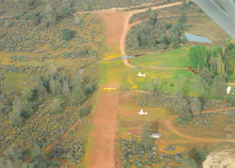
    The strip generally runs downhill with a few gentle hills in the runway. The runway is about 2000 ft long, the first 300 feet is unusable for landing but can be used for takeoff. Plan to land to the west normally.

    Liability waiver: https://docs.google.com/forms/d/1ZlPRJGtIXm5PuhdMwZK4OmZMx7b7Wo2cVzW0MoLxS4c/edit

    Runway
    • Length

      1500

    • Width

      45

    • Surface

      DIRT

    Details
    • Facility ID

      No ID 036

    • Elevation

      1000

    • CTAF

      122.9

    Gallery
    Location

    Lat: 37.86542300000 , Long: -120.48537600000 - CALIFORNIA, USA

    Get Directions
    Categories
    • Restricted
    Region
    • Western Pacific
    Ownership
    • Private
    Author
    shortfield

    Land here, before you land out there!

    • DennisB
      May 13, 2026 at 6:22 pm

      Our club West Coast Flyers arranged a fly in visit to Red Hills on 5/9/26 as part of our annual Gold Country Fly in at Columbia. 5 planes flew in to visit with Jack and Myrna. What an incredible visit it was. The two of them and their 14 yo dog Roy hung out with us for the better part of an hour telling stories and sharing laughs. They had cold drinks waiting and we sat around their table on the front porch. This was the highlight of the weekend for me. Prior permission is required. If you fill out the waiver on this site you can land there. A bit of information that is different than what the video says, the creek is a non issue now. They have installed a culvert and leveled the area so the full length is available for landing. I recommend going to Red Hills and meeting Jack and Myrna. They are very special and We won’t have them forever.

      Overall Rating

      Camping Facilities

      Runway Condition

      Recreational Opportunities

      Log in to Reply
    Add a review

    Leave a Reply · Cancel reply

    You must be logged in to post a comment.

    YouTube Search
    Prev 1 of 2238 Next
    • Red Hills Airstrip Safety Briefing

      Red Hills Airstrip Safety Briefing

      Red Hills Airstrip Safety Briefing

      Any pilot wanting to land at the Red Hills Airstrip should view this video to get an introduction to the operating procedures.

      Pilots are reminded to complete the liability waiver prior to landing.

      The liability waiver is available at:
      https://www.dropbox.com/s/np1xzlah4irx2s1/RedHillsSafetyBrief.mp4?dl=0
    • Red Hills Safety Brief Rev 5

      Red Hills Safety Brief Rev 5

    • Red Hills SafetyBrief Rev3

      Red Hills SafetyBrief Rev3

    • Leaked footage of a UFO seen rising from the ocean during a navy operation! Breaking news!

      Leaked footage of a UFO seen rising from the ocean during a navy operation! Breaking news!

      Leaked footage of a UFO seen rising from the ocean during a navy operation! Breaking news! #UFO #ufos #uaps #uap #Aliens #Alien #OVNI
    • We found ABANDONED Airplanes in NORTH CAROLINA! #urbex #abandonedexploration #airplane

      We found ABANDONED Airplanes in NORTH CAROLINA! #urbex #abandonedexploration #airplane

    • Hidden Airfield Near Garlock, California

      Hidden Airfield Near Garlock, California

      A video tour of an isolated dry lake in the Mojave desert near Garlock, California, which was supposedly used shortly after Pearl Harbor as a hiding place for fighter aircraft based at Muroc Army Airfield (now Edwards AFB), and Naval Air Station China Lake. However, after a tour of the place, I have my doubts. Terrain clearance (or lack of it, I mean), the short length of the runway (about 3100 feet), two deep depressions in the runway, its unusability during the rainy season, lack of parking space, no means of revetting aircraft or storing fuel and munitions, all point to the fact that this area would have been rather undesirable as an airport. Even if that had been its intended use, placing aircraft here would have had to be an act of near desperation, to be done only in the event the Japanese army was encroaching on the military airfields in the area. In my opinion, pierced steel plating would not have worked in the rainy season here, due to the sheer depth and extremely low bearing strength of the wet silt of this lakebed. Even had the runway been paved, it would, in my opinion, have been under water and therefore unusable. However, the BLM naturalist at Jawbone Station was adamant that this area had, in fact, been used as a hiding place for fighter aircraft based in the area. I don't know what to think. If you have any information on this area, please feel free to post it here on YouTube or e-mail me at mojaveroads@live.com.
    Prev 1 of 2238 Next

    You May Also Be Interested In

    Salt Springs Valley Strip, CA

    Flew over this strip and got a wave in from the Owner.  It serves as an R/C airstrip every Tuesday and…
    • 38.04287283218, -120.69393173380
    • Recreational

    J-B, CA

    J-B is a private airstrip built on a golf course. The strip is owned by Jim Boone and avid golfer and pilot.…
    • 37.93520250000, -121.01549444444
    • Restricted

    Robbins Skyranch, CA

    • 38.21675912534, -120.91098681613
    • Recreational

    © 2000-2025 shortfield.com

    Cart

      • Featured
      • Recreational
      • Restricted
      • Off-Airport
      • Abandoned
      • Outpost
      • Facebook
      • Twitter
      • Mail
      • Copy link