Sign in or Register
    • Featured
    • Recreational
    • Restricted
    • Off-Airport
    • Abandoned
    • Outpost
    • Home
    • Explore
    • STOL Gear

    PEAVINE, AK

    • Overview
    • Reviews / PIREPs 0
    • Videos
    • Events
    • prev
    • next
    • Leave a Review / PIREP
    • Bookmark
    • Report
    • Share
    • prev
    • next
    Description

    Peavine Cabins — Public-Use Coordinates: N61.452471, W142.486578 USGS Maps: McCarthy 1:250,000 | McCarthy 1:63,360 (B-4)

    The Cabins

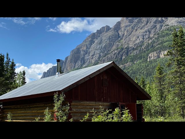
    Two rustic cabins sit on a gravel bar of the Chitistone River, 14 miles east of McCarthy, framed by towering cliffs on all sides.

    Peavine #1 (20×24) accommodates up to 6 guests and is handicap accessible. It features six twin wooden bunks, a table with benches, a wood stove, fire extinguisher, information bulletin board, and a pit toilet.

    Peavine #2 (14×16) accommodates up to 3 guests. It includes one twin and one double wooden bunk, a table with benches, a wood stove, fire extinguisher, information bulletin board, and a pit toilet.

    Access
    Fly in via the nearby 1,650-foot gravel airstrip. In winter, access is by snowmachine.

    Recreation
    The setting is spectacular — dramatic cliff scenery surrounds the site, and old mining trails on nearby hillsides offer easy day hikes.

    Things to Know
    Bugs are significant in this area. Head nets are strongly recommended from June through August. Firewood should be gathered from dead and downed wood on-site.

    Runway
    • Length

      1600

    • Width

      ?

    • Surface

      GRAVEL

    Details
    • Facility ID

      No ID 077

    • CTAF

      122.9

    Gallery
    Location

    Lat: 61.45714600000 , Long: -142.47036000000 - ALASKA, USA

    Get Directions
    Flyover Video
    Prev 1 of 1 Next
    • Runway Flyover - Peavine, Alaska

      Runway Flyover - Peavine, Alaska

      @shortfieldvideos
    Prev 1 of 1 Next
    Categories
    • Recreational
    Region
    • Alaska
    Ownership
    • Public
    Author
    shortfield

    Land here, before you land out there!

    mood_bad
  • No reviews/PIREPs have been posted yet.

  • Add a review

    Leave a Reply · Cancel reply

    You must be logged in to post a comment.

    Shortfield Playlist
    Prev 1 of 1 Next
    • Wolverine airstrip, Alaska

      Wolverine airstrip, Alaska

      Depart Peavine airstrip; Land Wolverine Airstrip to the W of McCarthy, Alaska. Have to do this on a low wind day as it is up on a mountain top. Definitely one of the coolest places I've ever landed!
    • Peavine Strip and Public Use Cabin-Alaska | Geoff Oliver

      Peavine Strip and Public Use Cabin-Alaska | Geoff Oliver

      Peavine Strip and Public Use Cabin in the Wrangell Mountains east of McCarthy, Alaska on the Chitistone River. This shows landing both east and west directions, the cabin, and taking off west. The large cabin has 3 bunk beds and sleeps 6 and the smaller cabin sleeps 3.
    • Peavine Bar

      Peavine Bar

      departure from Peavine Bar, near McCarthy, Alaska
    • Morning Time Lapse At Peavine Bar, Alaska

      Morning Time Lapse At Peavine Bar, Alaska

      A simple morning time lapse at Peavine Bar in Alaska near McCarthy
    • Bush Flying/Camping in Wrangell St. Elias National Park

      Bush Flying/Camping in Wrangell St. Elias National Park

      Thank you for watching, please subscribe!

      This week I flew over to the Wrangell-St. Elias National Park and Preserve in Alaska. I left Merrill Field in Anchorage, Alaska and flew up the Matanuska river and then towards Gulkana, Alaska. I refueled my plane in Gulkana and then headed towards the National Park. Instead of landing in McCarthy, I headed straight to one of the Public Use cabins. The cabins are called the Peavine cabins, they have their own airstrip. It was a really beautiful view here, the mountains seemed much different than in the Chugach and Talkeetna ranges that I'm used to flying in. The next day I flew over to McCarthy, Alaska and viewed the Kennecott glacier and mine from the air. First class views. I refueled there prior to heading back towards Gulkana. About 30 miles out of Gulkana I started running into heavy wildfire smoke and also thunderstorms, which made the trip pretty sketchy. Once in Gulkana I really thought about whether or not I wanted to proceed onward towards Anchorage or sit it out. I got a good look at the weather, using Foreflight, I was able to see the locations of the storm cells. My main concerns were first being able to make it to the Eureka Roadhouse area and second that the pass through the Matanuska area was going to be safe. I played everything really slow and safe, always giving myself an out. I hope you enjoyed our video, thank you for watching!

      7:11-11:15 song 'Alaska And Me' by John Denver, covered by @TheSongery

      #Alaska #BushFlying #BushPilot #Pilot #BushPlane
    Prev 1 of 1 Next

    You May Also Be Interested In

    GLACIER CREEK, AK

    A public use cabin is located near the airstrip:Cabin location: N61.455, W142.375Refer to USGS maps, McCarthy…
    • 61.45513444444, -142.38095083333
    • Recreational

    Nikolai Pass, AK

    High mountain, off-airport landing site in Alaska's Wrangell-St. Elias National Park.
    • 61.465529, -142.648697
    • Off-Airport

    Wolverine, AK

    Perched on a high plateau deep within Wrangell-St. Elias National Park, the Wolverine backcountry airstrip is…
    • 61.509413, -142.296256
    • Recreational

    © 2000-2025 shortfield.com

    Cart

      • Featured
      • Recreational
      • Restricted
      • Off-Airport
      • Abandoned
      • Outpost
      • Facebook
      • Twitter
      • Mail
      • Copy link